Storm and sanitary sewers work by gravity. If a pipe is laid too flat, sloped the wrong way, or set at the wrong depth at a manhole, the line will not drain as designed, and the only real fix is to dig it up. That is why pipe layout is one of the most demanding jobs a construction surveyor does on a civil site.
This guide walks through how a pipe layout survey is done for storm and sanitary sewers: what the surveyor needs before staking, how manholes and offset stakes are set, how cuts to invert are calculated, and how inverts are recorded for as-built drawings. It is written for contractors, foremen and project managers working on underground utilities in BC.
Key Takeaways
- A pipe layout survey marks manholes, structures and the pipe alignment with offset stakes, each with a cut to the design invert.
- Gravity pipe depends on slope, so small grade errors can cause standing water, reduced capacity and failed inspections.
- Stakes are offset from the trench so they survive excavation; the crew transfers line and grade from them.
- Inverts and rim elevations should be surveyed before backfill so the as-built record is accurate.
- Site Wiz completes pipe layout in the field across BC and prepares cut sheets and record drawings for contractors anywhere in Canada.
What Is a Pipe Layout Survey?
A pipe layout survey transfers the design of an underground pipe from the drawings to the ground. The surveyor marks the location of each manhole, catch basin and other structure, then sets a line of stakes along the pipe route. Each stake carries its station, its offset to the pipe centreline and the cut from the stake down to the design invert, the inside bottom of the pipe.
The crew uses that information to dig the trench to the right depth, prepare the bedding and set each length of pipe on line and on grade. On most sewer jobs, the pipe crew also uses a pipe laser set to the design slope, and the survey stakes are the reference used to set and check it.
Why Gravity Pipe Leaves Little Room for Error
Water mains are under pressure and can follow the ground. Storm and sanitary sewers cannot. They rely on a continuous downhill slope between manholes, and many lines are designed close to the minimum slope allowed, especially on flat sites or long runs.
On a gentle grade, a few centimetres of error can create a flat spot or a back-fall where water and solids collect. Problems like this are often found when the line is video-inspected before the municipality accepts it, and by then the pipe is already backfilled. Getting the layout and the grade checks right during installation is far cheaper than excavating and relaying pipe later.
What the Surveyor Needs Before Staking
- Current issued-for-construction drawings: plan and profile sheets with manhole stations, inverts, pipe sizes, materials and slopes, plus the digital design files where available.
- Site control: reliable horizontal and vertical control points tied to the project coordinate system. See our guide to the construction survey control network.
- Existing utilities: locate information and the elevations of any pipes or cables the new line will cross.
- The crew’s preferences: which side of the trench the stakes should go, the offset distance, and the interval between stakes.
Before any stakes go in, it is worth checking that the design inverts tie in correctly at the connection to the existing main. A connection manhole that is higher or lower than shown on the drawings changes the whole profile, and it is much easier to resolve with the engineer before the first pipe is laid.
How Sewer Pipe Is Staked, Step by Step
1. Manholes and structures
Each manhole is located from control and marked with offset stakes, often two stakes on a line through the manhole centre, so the centre can be re-established after excavation. Each stake shows the cut to the invert of the outgoing pipe, and sometimes the rim elevation.
2. Offset line along the pipe
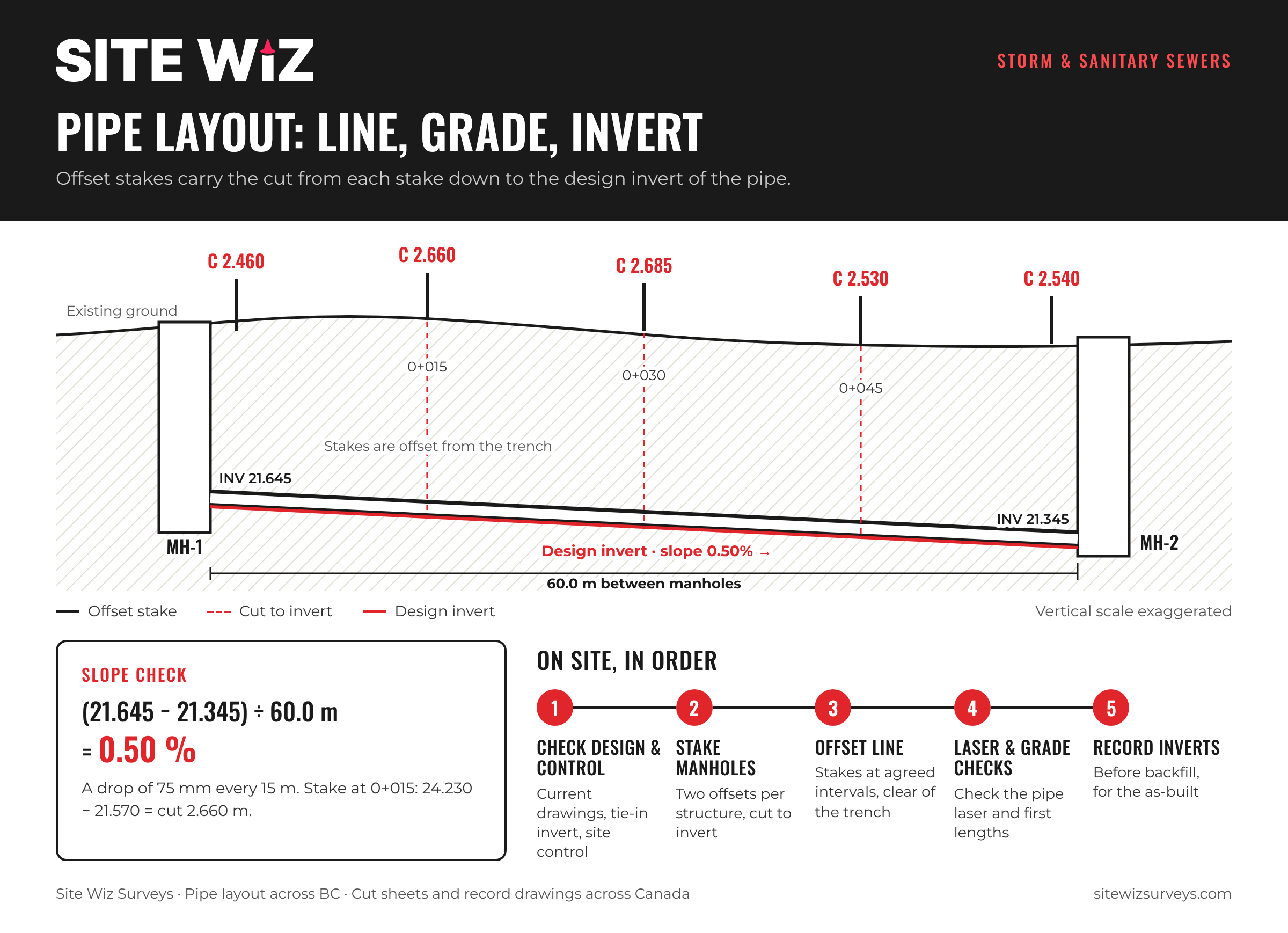
Between manholes, stakes are set on one side of the pipe at a fixed offset and at regular intervals agreed with the crew. The offset keeps the stakes clear of the trench and the spoil pile, so they survive the dig.
3. Cuts to invert
For every stake, the surveyor calculates the design invert at that station and subtracts it from the stake elevation. The result is the cut, written on the lath and listed on a cut sheet. Our guide on how to read construction cut sheets explains the format in detail.
4. Setting the laser and grade
The pipe crew typically sets a pipe laser in the downstream manhole at the design invert and slope. The surveyor can check the laser line against the stakes before the first lengths are laid, which catches set-up errors early.
5. Checks during installation
After the first few lengths, and at regular points along the run, the invert or top of pipe is checked against design. Catching a drift of a few millimetres at this stage takes minutes; finding it after backfill takes days.
Calculating Pipe Slope: A Worked Example
Pipe slope is the drop in invert divided by the horizontal distance, expressed as a percentage. Take a 60.0 m run between two manholes. The invert at the upstream manhole is 21.645 m and at the downstream manhole 21.345 m.
(21.645 − 21.345) ÷ 60.0 = 0.0050, or a slope of 0.50%. That means the invert drops 75 mm every 15 m. If a stake at station 0+015 has an elevation of 24.230 m, the design invert there is 21.570 m, so the cut is 24.230 − 21.570 = 2.660 m.
Service Connections and Utility Crossings
Most sewer mains also carry service connections to each lot. These are usually staked at the property line with a cut to the service invert, so the service can be installed at a depth that will drain the future building. The location and invert of every service should be recorded, because the next contractor on site will need to find it.
Where the new pipe crosses existing utilities, the surveyor checks the design clearance against the actual elevation of the existing line once it is exposed. If the clearance does not work, the engineer needs to know before the pipe reaches that point. Our article on utility construction layout and conflict avoidance covers this in more detail.
Recording Inverts for As-Built Drawings
Before the trench is backfilled, the surveyor should record the inverts at each manhole, the rim elevations, the location of fittings and the ends of service connections. These measurements become the record of what was actually built.
Municipalities and owners rely on this information for acceptance and for future maintenance. A missing invert is very hard to recover once the pipe is buried. Learn more about as-built record drawings in BC.
How Site Wiz Supports Pipe Installation
On projects in Victoria, on Vancouver Island and across BC, our field team stakes manholes, structures and pipe runs, checks grades during installation and records inverts for the as-built package. These are part of our construction layout and as-built survey services.
For contractors anywhere in Canada, our office team can prepare pipe cut sheets and layout drawings from your design files, and turn your field data into as-built record drawings.
Planning a storm or sanitary installation? Contact Site Wiz with your drawings and schedule, and we will help you plan the layout before the first trench is opened.
Frequently Asked Questions
How far apart are offset stakes on a sewer line?
It depends on the project specification and the crew’s preference. Stakes are always set at manholes and structures, with additional stakes at regular intervals between them, agreed with the foreman before layout.
Why are pipe stakes offset instead of placed on the centreline?
Stakes on the centreline would be destroyed when the trench is dug. Offset stakes stay in place, and the crew measures across from them to find the pipe line and grade.
Who sets the pipe laser?
Usually the pipe crew sets and maintains the laser. The surveyor provides the reference points and can check the laser line against design before and during installation.
Can the pipe grade be checked after installation?
Yes. Inverts at manholes and key points are surveyed before backfill. This confirms the slope and provides the data for as-built drawings.
Does Site Wiz lay out water mains as well?
Yes. Water mains are laid out with offset stakes and depth of cover rather than a fixed slope, and they are included in our utility layout work across BC.