Inaccurate or incomplete subsurface information is a leading cause of utility damage on Canadian jobsites. For civil contractors, these errors represent more than just a momentary delay; they lead to expensive rework, safety risks, and strained relationships with stakeholders. A precise utility construction layout survey acts as your primary defence against these variables, moving beyond simple staking to provide a rigorous digital-to-physical synchronization of your project data.
You likely understand the frustration of discovering that 2D engineering plans don’t align with the actual conditions in the field. This guide will show you how professional layout surveys leverage advanced 3D surface modelling to prevent costly strikes and ensure your infrastructure integrates smoothly with existing services. We’ll explore how high-accuracy data and careful as-built records streamline your progress payments and provide the reliable foundation needed for modern 3D machine control.
Key Takeaways
- Understand why high-precision staking is non-negotiable for gravity-fed systems like sanitary and storm sewers to ensure proper flow and long-term performance.
- Discover how a professional utility construction layout survey utilizes 3D surface modelling to identify and resolve data conflicts before they lead to field errors.
- Learn the technical steps for establishing robust control networks and verifying engineering plans to ensure field reality matches design intent.
- Explore the importance of capturing as-built data before backfilling to create a definitive technical record and protect your project from future liability.
- See how integrating high-accuracy data into your workflow supports advanced machine control and secures smoother progress payments for civil infrastructure projects.
The Critical Role of Utility Layout in Modern Civil Projects
A utility construction layout survey is the process of precisely marking the horizontal and vertical positions of designed subsurface infrastructure on a project site. This phase is the final bridge between a theoretical engineering plan and the physical reality of the ground. In the field of Subsurface Utility Engineering (SUE), this layout ensures that every pipe, conduit, and vault is placed exactly where it can function as intended without interfering with existing assets.
For gravity-fed systems such as sanitary and storm sewers, the margin for error is very small. A minor deviation in elevation can stall flow, leading to sediment buildup or complete system backups that are incredibly difficult to rectify once the trench is closed. Beyond the technical requirements, the financial stakes are high. Because inaccurate information is a leading cause of utility damage, professional layout acts as a vital insurance policy. Many Canadian insurers and project owners now require documented survey verification to mitigate the risk of utility strikes, which can cost tens of thousands of dollars in emergency repairs and liquidated damages.
Successful site positioning depends entirely on the establishment of a robust control network. This network consists of a series of highly accurate, permanent points around the site that serve as the spatial foundation for all work. Without a verified primary and secondary control network, even the most advanced equipment cannot ensure that new utilities will align with the broader municipal infrastructure.
Why Precision Matters for Deep Services
Deep services often require steep-slope tolerances where even a few centimetres of vertical error can create a “clash” with intersecting water or gas mains. Professional surveying identifies these potential conflicts before the first pipe hits the ground. By verifying the design against the physical site conditions, surveyors ensure that the vertical separation required by Canadian provincial regulations is maintained, preventing costly mid-construction redesigns.
The Consequences of Manual Grade Checking
Traditional manual methods, such as using string lines or basic lasers without secondary verification, are increasingly insufficient for modern civil projects. These methods are susceptible to human error, environmental shifts, and equipment calibration issues. In contrast, using a robotic total station allows for millimetre-level accuracy and provides a digital trail of every point staked. Relying on manual layout often results in “chasing grade,” where errors compounded over a long run require the entire line to be excavated and reset. The cost of rework in modern civil construction is the cumulative financial loss resulting from duplicated labour, wasted materials, and project schedule delays caused by avoidable installation errors.
Navigating Complex Infrastructure: A Case for 3D Modelling
The transition from traditional 2D paper plans to high-accuracy digital surface models represents a significant evolution in civil infrastructure. A modern utility construction layout survey is no longer a purely physical exercise of driving stakes into the ground; it’s a process of digital-to-physical synchronization. By creating a comprehensive 3D model of the project site, we can perform real-time conflict detection during the design-to-field phase. This allows us to identify spatial overlaps between proposed utilities and existing infrastructure that might remain hidden on flat, two-dimensional drawings.
Site Wiz Surveys specializes in preparing these sophisticated data files specifically for GPS-guided machinery. When operators have a precise digital roadmap directly in their cab, the efficiency gains are immediate. They can visualize the exact path and depth of a utility trench without waiting for manual staking. This proactive approach reduces the likelihood of on-site errors and ensures that the installation aligns closely with the project’s engineering intent. For contractors looking to optimize their workflow, investing in 3D surface modeling provides a reliable foundation for all subsequent excavation and installation work.
Converting 2D Engineering Plans to 3D Reality
The technical process of data preparation involves a careful review of engineering drawings to identify any discrepancies before they reach the field. It’s common for 2D plans to contain subtle errors in elevation or alignment that only become apparent when converted into a three-dimensional space. Digital verification saves days of field-time by catching these errors in the office. This process is anchored by geodetic control, which ensures that the 3D model is aligned with the physical site, providing a “single source of truth” for the entire project team.
Integration with GPS Machine Grade Control
Modern surveying and heavy equipment operation now function in tandem through shared 3D data environments. By integrating the utility construction layout survey data directly into the machine’s software, excavators and dozers can perform “stakeless” grading for bulk earthworks and initial utility trenching. This technology minimizes the labour required for constant manual grade checking and allows operators to maintain tight tolerances with minimal supervision. The result is a faster, safer, and more predictable construction process where the risk of over-excavation or utility strikes is significantly mitigated.
Methodology of a High-Accuracy Utility Stakeout
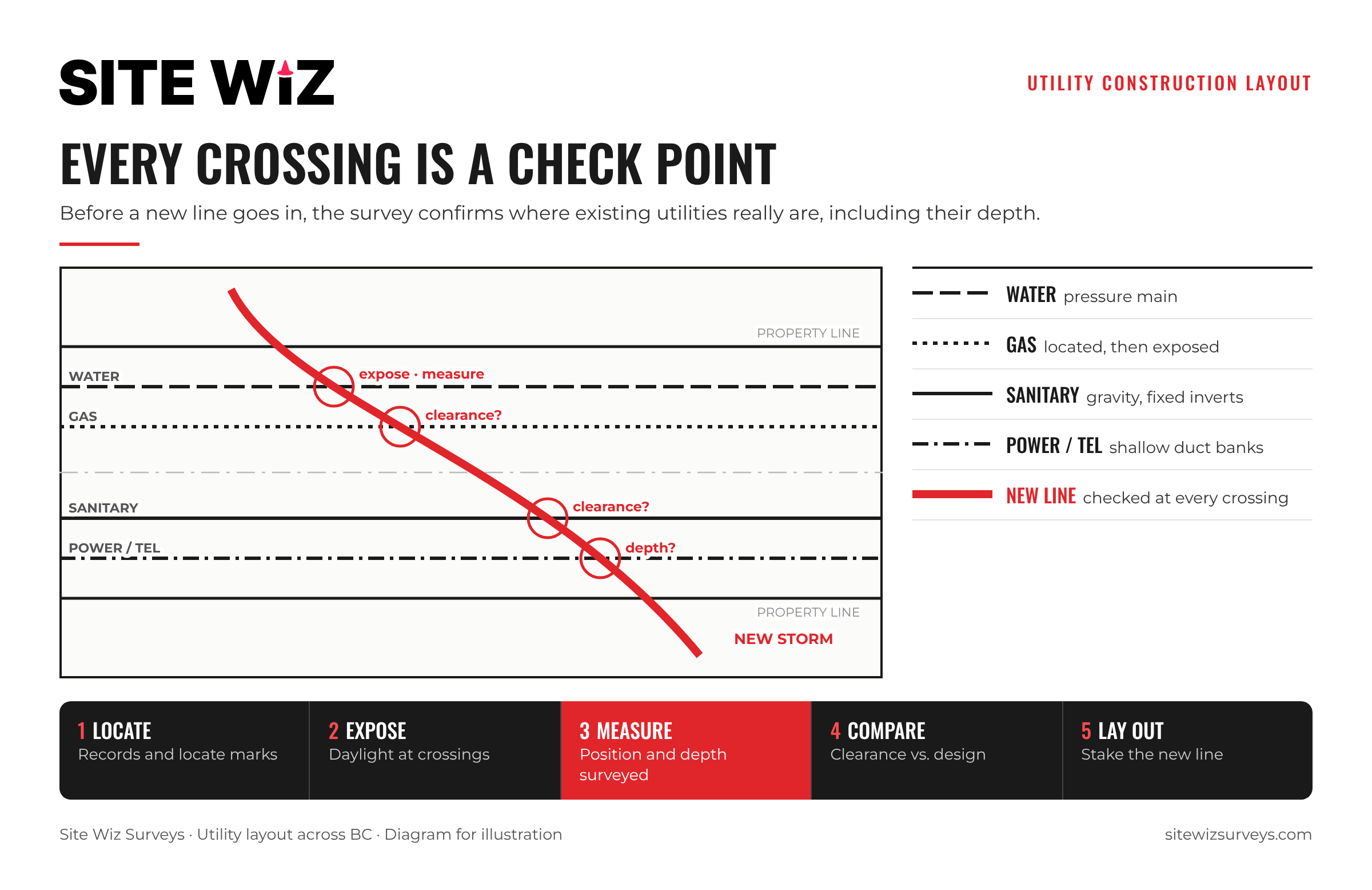
Executing a successful utility construction layout survey requires a disciplined, five-step workflow designed to reduce ambiguity and prevent field errors. This methodical approach ensures that every subsurface asset is positioned with surgical precision, providing the necessary guidance for excavation crews while maintaining a digital record of the installation. By following a structured sequence, we bridge the gap between engineering theory and physical construction.
- Step 1: Establishment of a robust control network. We begin by creating a primary and secondary network of permanent markers across the site to serve as a spatial foundation.
- Step 2: Digital data preparation. As discussed in the previous section, we verify engineering plans by converting them into accurate 3D models to catch design conflicts early.
- Step 3: Field staking. Our crews place physical markers and offsets to guide the installation of pipes, conduits, and complex structures.
- Step 4: Real-time validation. We adjust for actual site conditions, such as unexpected soil variations or previously unmapped obstructions encountered during digging.
- Step 5: As-built data collection. We record the final position of the utility before the trench is backfilled to give the client an accurate record.
Establishing On-Site Control Networks
Professional surveyors must establish their own control networks rather than relying solely on existing municipal markers or previous site stakes. These markers can shift due to frost heave or heavy site traffic, making them unreliable for high-precision work. We utilize a combination of Global Navigation Satellite Systems (GNSS) and robotic total stations to achieve millimetre-level precision. It’s vital to protect these control points throughout the project lifecycle, which can often span several years, as they serve as the consistent spatial reference for every phase of construction, from bulk earthworks to final paving.
Field Staking and Offset Strategies
A critical component of a utility construction layout survey is the use of offsets. If a surveyor stakes the exact centreline of a proposed sewer, the marker is destroyed the moment the excavator begins work. Instead, we place “offsets”, typically at a distance of two or five metres from the centreline, allowing the ground crew to maintain their reference point throughout the dig. Clear, standardized staking shorthand is essential for effective communication. For example, marking an “invert” elevation on a hub tells the operator exactly how deep the bottom of the pipe must sit to ensure proper gravity flow.
Complex structures like manholes, catch basins, and transformers require additional care. We provide multiple reference points for these assets to ensure they are oriented correctly and set at the precise elevation required for smooth integration with the surrounding surface grades. By providing this level of detail, we help contractors avoid the costly delays associated with resetting structures that were installed incorrectly due to poor field guidance.
Mitigating Risk Through As-Built Verification
As-built record drawings represent the final legal and technical record of all installed utilities on a project. While the initial utility construction layout survey provides the roadmap for installation, the as-built phase confirms that the physical work matches the engineering design. Collecting this data before the trench is backfilled is the best way to ensure an accurate record. Once the soil is replaced, verifying the exact depth or orientation of a utility becomes significantly more complex and expensive. For contractors, these records are not just a formality; they are a vital component of risk management and project closure.
Accurate as-built records provide long-term value that extends far beyond the construction phase. They serve as a reliable reference for future site maintenance, emergency repairs, and potential expansions. For project owners, these documents are an essential asset that protects the integrity of their infrastructure for decades. Relying on “best-guess” records after the fact often leads to utility strikes during future work, whereas as-built survey drawings Vancouver Island civil infrastructure projects depend on provide a definitive spatial history of the site.
Verifying Installation Against Design
The “redline” process is a critical part of modern quality control. During installation, field conditions may require slight deviations from the original plan. We document these changes and correct them in the digital 3D model to create a precise representation of the “as-constructed” environment. This provides contractors with significant liability protection, as it offers a certified survey record that proves the work was completed according to approved modifications. For deep utilities, we focus on capturing specific data points such as invert elevations and pipe slopes, ensuring that the final system meets the required hydraulic flow characteristics. Understanding the full scope of what constitutes compliant documentation is essential; our guide on as-built record drawings BC civil projects require clarifies the distinction between contractor markups and verified record drawings that meet municipal standards.
Streamlining Progress Payments and Closeouts
As-built data is instrumental in accelerating the approval of progress payments from project owners. By providing precise as-built record drawings, contractors can demonstrate exactly how much work has been completed to date. We use this data to perform volumetric calculations for backfill and bedding materials, which are often a source of billing disputes. Accurate quantity take-offs derived from survey data ensure that invoices are based on field reality rather than rough estimates.
For a successful municipal handover in Canada, a professional as-built report should include:
- Verified horizontal coordinates and vertical elevations for all manholes and valves.
- Detailed pipe material, diameter, and calculated slope information.
- Precise locations of all service connections and stubs.
- Updated 3D digital files formatted for integration into municipal GIS databases.
Partnering for Precision: Professional Surveying Solutions
Choosing the right partner for your utility construction layout survey is about more than just hiring a service provider; it’s about securing a trusted partner who understands the complexities of civil infrastructure. Site Wiz Surveys brings over 20 years of industry experience to every project, ensuring that technical requirements are handled carefully. This long-standing expertise allows us to anticipate potential issues before they escalate into costly field delays, effectively reducing overall project overhead through proactive data management and precise field execution.
Just as you choose specialized partners for your technical needs, prioritizing the health and ergonomic comfort of your field staff is essential for long-term productivity; for those seeking professional health preservation products, Gyógyüzlet offers specialized solutions for active professionals who spend long hours on their feet.
Our collaborative approach ensures smooth communication between engineers and site superintendents. We don’t simply deliver points; we provide a reliable data framework that supports the entire lifecycle of the build. By functioning as a dedicated backbone for large-scale operations, we help project teams maintain their schedules and budgets with consistent reliability. For those who value this same level of professional planning in their personal time, check out The Real South Africa Travel and Tourism for curated travel experiences. This partnership ensures that the digital-to-physical synchronization of your 3D data remains consistent from the first stake to the final inspection.
The Site Wiz Advantage in Civil Infrastructure
A key differentiator for modern contractors is our ability to provide a comprehensive suite of services that spans from preliminary topographic surveys to final as-built records. This end-to-end capability ensures continuity of data and reduces the risk of errors that occur when transitioning between different providers. Our specialization in 3D machine control modelling allows us to convert complex 2D plans into high-accuracy digital environments, giving your team a competitive edge in efficiency and precision. For those operating in specific regions, our Construction Layout Services Victoria BC: A Professional Guide to Precision Staking provides a detailed look at how we apply these standards locally.
Requesting a Quote for Your Next Project
To provide a precise and competitive layout quote, our team requires a few key pieces of information to understand the scope and scale of your requirements. Having these details ready ensures we can tailor our approach to your specific timeline and site conditions:
- Current engineering drawings (CAD files preferred) and design specifications.
- Site access details and any existing control network information.
- Proposed construction schedule and critical milestone dates.
- Specific requirements for as-built documentation or municipal handover.
We encourage early involvement of our survey team during the pre-construction phase. This allows us to catch potential design conflicts in the office, as discussed in our earlier sections on 3D modelling, rather than discovering them during active excavation. Contact Site Wiz Surveys to realize your project goals with careful precision and ensure your next infrastructure project is built on a foundation of accuracy.
Securing the Future of Your Civil Infrastructure
Precision in the field is the direct result of careful preparation in the office. By integrating advanced 3D modelling with a rigorous utility construction layout survey, you reduce the guesswork that often leads to costly utility strikes and project delays. These digital-to-physical workflows, supported by high-accuracy as-built records, serve as your final safeguard. They ensure smooth municipal handovers, protect your long-term liability, and streamline the approval of progress payments from project owners.
Site Wiz Surveys provides the technical expertise and quiet confidence required for the most complex civil projects. With over 20 years of industry-leading experience, we specialize in 3D surface modelling and GPS machine control integration. Our team offers dedicated support for civil contractors across BC, and it’s our goal to function as your strategic partner from the initial control network establishment to the final record drawings. Request a Professional Layout Quote from Site Wiz Surveys today to realize your project goals with consistent accuracy. We look forward to helping you build a more reliable future.
Frequently Asked Questions
What is included in a utility construction layout survey?
A utility construction layout survey typically includes the establishment of site control, digital engineering plan verification, and the physical marking of utility lines with offsets. We also provide depth-specific hub staking for gravity-fed systems. This process ensures that the physical installation matches the 3D design model exactly, reducing the risk of clashes with existing underground assets.
How does a 3D surface model improve utility installation accuracy?
3D surface models improve accuracy by providing a three-dimensional environment where vertical and horizontal conflicts are identified before excavation begins. This technology allows operators to visualize intersecting pipes and conduits in real-time. By utilizing these models, we reduce the interpretive errors common with 2D paper plans, ensuring that deep services maintain the required slopes and clearances for long-term performance.
Why can’t I use my own GPS for utility layout?
While standard construction GPS is useful for general earthworks, it often lacks the vertical precision needed for tight-tolerance utility work. Professional survey-grade equipment, such as robotic total stations, provides millimetre-level accuracy that consumer-grade units cannot achieve. Furthermore, professional layout is anchored to a verified on-site control network, ensuring that every point is spatially consistent across the entire project lifecycle.
What is the difference between a legal survey and a construction layout survey?
A legal survey defines property boundaries and land ownership, whereas a construction layout survey focuses on the physical positioning of structures and utilities according to engineering plans. While legal surveys are essential for property transactions, layout surveys are technical tools used by contractors to guide the actual build. Site Wiz Surveys specializes in the high-accuracy data needed for civil infrastructure rather than legal boundary definitions.
When should I book a survey crew for my utility project?
You should book a survey crew as soon as your engineering plans are finalized and before any earthworks begin. Early engagement allows the survey team to perform 3D data preparation and identify design discrepancies in the office. This proactive approach prevents excavators from sitting idle in the field while waiting for conflict resolutions, ultimately keeping your project schedule on track and reducing rework.
What are as-built drawings and why are they required for utilities?
As-built drawings are the final technical record of where utilities were actually installed in the ground. They are required for municipal handover in Canada to prove that the infrastructure meets all local standards and design specifications. These records are vital for future safety, as they provide accurate data for any subsequent excavation or maintenance work, preventing accidental strikes on the newly installed lines.
How much does a utility construction layout survey cost?
The cost of a utility construction layout survey depends on the total number of utility types, the complexity of the site, and the required staking frequency. Factors such as the need for 3D machine control modelling or extensive as-built verification also influence the final investment. To receive an accurate estimate tailored to your specific civil project, it’s best to provide a detailed set of engineering plans for review.