A single discrepancy between a digital plan and a buried utility can compromise months of progress and thousands of dollars in project margin. While many view the final documentation as a mere administrative hurdle, high-precision as-built survey drawings Vancouver Island infrastructure projects depend on are actually critical risk-mitigation tools. You likely recognize the frustration of project closeout delays or the anxiety of potential utility strikes caused by outdated or vague records. These issues don’t just stall payments; they create a cycle of costly rework that erodes trust with municipal partners and engineers.
It’s possible to transform this final stage into a strategic advantage by mastering specific technical standards and digital submission requirements used across the region. This guide provides a clear framework for accurate data collection and precise utility mapping to ensure your project meets the rigorous expectations of local authorities. We’ll examine the necessary steps to reduce your professional liability, accelerate approval timelines, and realize the full value of a high-accuracy digital twin for long-term asset management. By aligning your field data with modern standards, you can secure faster progress payments and protect the lifecycle of the infrastructure you build.
Key Takeaways
- Learn why high-accuracy as-built survey drawings Vancouver Island projects require are the definitive record for future maintenance and infrastructure expansion.
- Understand the technical necessity of horizontal and vertical control points to ensure geographic precision for road centrelines and buried utilities.
- Discover how modern 3D data acquisition and GNSS technology provide superior accuracy over traditional manual measurements for complex civil sites.
- Master the specific municipal and provincial drafting standards required to navigate the project closeout and approval process across British Columbia efficiently.
- Reduce professional liability by utilizing precise record drawings that serve as a reliable digital twin for long-term facility and asset management.
Understanding As-Built Survey Drawings in the Civil Infrastructure Lifecycle
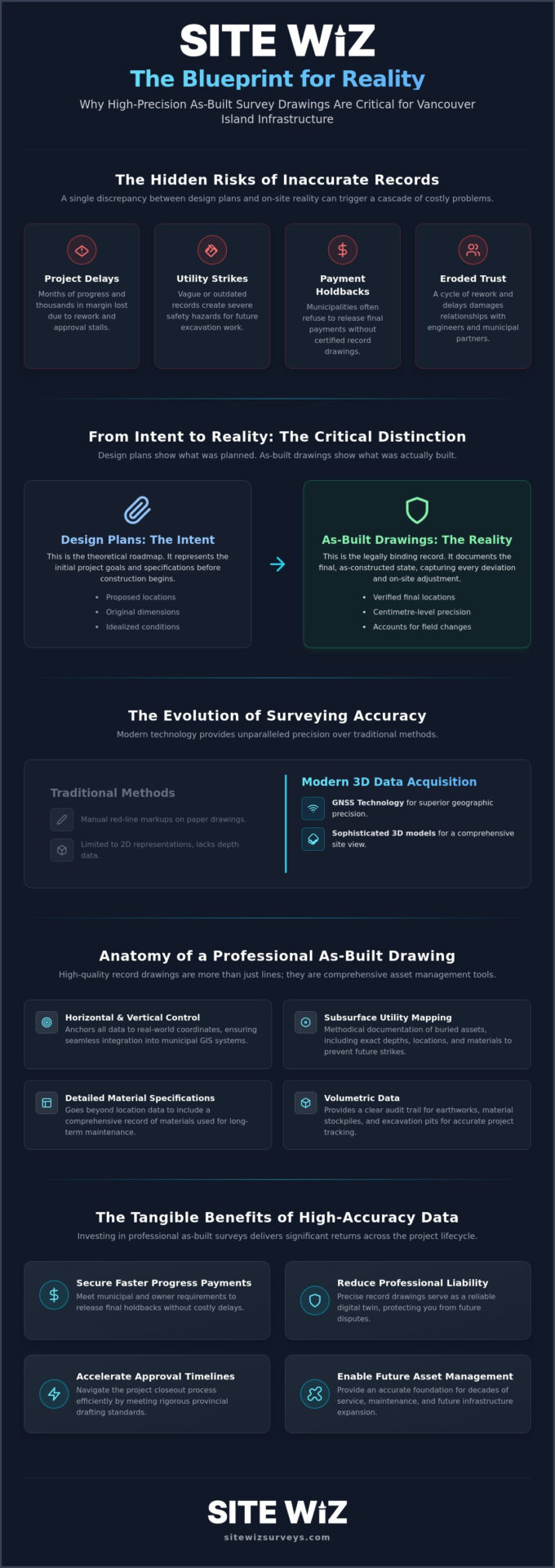
In the lifecycle of any infrastructure project, the transition from the theoretical design to the physical reality is rarely a mirror image. An As-built survey serves as the definitive bridge between these two phases. It documents the final location, dimensions, and elevations of all constructed features. For contractors and developers, as-built survey drawings Vancouver Island teams rely on are more than just a closing requirement; they are a vital asset for long-term maintenance. As infrastructure evolves, these drawings provide the foundation for future expansions and site modifications.
The industry has moved beyond manual red-line markups on paper sets. We now utilize sophisticated digital 3D models that offer a comprehensive view of the site’s final state. Capturing every deviation from the original design intent is essential for liability protection. If a pipe was diverted to avoid a boulder, that change must be documented with centimetre-level precision. This protects the project owner and the contractor from future legal or operational disputes. Accurate records ensure that the “as-constructed” reality is preserved for decades of service.
This focus on accurate documentation and design integrity is equally important in the residential sector. For those looking for high-end residential construction and design in the Toronto area, NOORICO provides specialized services that ensure every project is built to the highest standards of precision and quality.
The Distinction Between Design Plans and Record Drawings
In complex civil environments, “as-planned” rarely matches “as-built” perfectly. Unforeseen site conditions often necessitate immediate adjustments. Common factors causing these modifications include unexpected soil density, unmapped utility conflicts, or logistical site constraints that weren’t visible during the initial topographic survey. While design plans provide the roadmap, they don’t reflect the final truth of the terrain. The record drawing represents the legally binding final state of the asset. Understanding the critical distinction between contractor markups and verified as-built record drawings BC municipalities accept is essential for ensuring your documentation meets the rigorous standards required for project closeout.
Why Civil Contractors Prioritize Accurate As-Built Data
For civil contractors, the accuracy of these drawings directly impacts the bottom line. Most municipalities and project owners will not release final progress payments or project holdbacks until they receive a certified set of record drawings. Beyond the financial aspect, precise data is a safety requirement. It prevents future utility strikes during subsequent site work or adjacent developments. By integrating professional Utility Construction Layout Survey data into the final as-built, teams can ensure that every buried asset is accounted for with total confidence. This proactive approach to data management reduces the risk of rework and ensures a smoother handover to the facility managers who will oversee the infrastructure for its entire functional life.
Essential Components of Professional As-Built Documentation
Professional documentation begins with the establishment of rigid horizontal and vertical control points. These coordinates act as the anchor for every data point collected on-site. When producing the as-built survey drawings Vancouver Island municipalities require, these control networks ensure that the digital record aligns perfectly with real-world geographic coordinates. This precision allows for the seamless integration of various infrastructure elements, including road centrelines, drainage structures, and complex utility networks. Without a verified control network, even the most detailed data remains a floating set of points that cannot be reliably integrated into broader municipal GIS systems.
A high-quality record drawing goes beyond simple location data. It must include detailed material specifications and exact installation depths. For earthworks, the inclusion of volumetric data for material stockpiles and excavation pits provides a clear audit trail of the project’s physical progress. This level of detail transforms a standard drawing into a comprehensive asset management tool. Partnering with a specialist for high-accuracy survey data ensures these essential components are captured with meticulous care, providing the clarity needed for long-term project success.
Utility and Subsurface Infrastructure Mapping
Documenting subsurface assets requires a methodical approach that leaves no room for ambiguity. Standards dictate the inclusion of pipe diameters, material types, and precise invert elevations at every manhole location. We prioritize “exposed” utility surveying, where data is captured while the trench is still open. This method guarantees centimetre-level accuracy that simply cannot be replicated once the ground is backfilled. These precise records serve as a digital twin, allowing facility managers to visualize buried infrastructure without the need for exploratory digging or risking utility strikes during future maintenance.
When these buried assets include potable water systems or rainwater collection tanks, it is also vital to verify the quality of the water they carry; for expert laboratory analysis, you can visit AWARE Water Testing to learn more about their testing services.
Topographic and Grading Verification
Verifying the final site grading against the original 3D design surface is a critical step in project validation. Drainage slope verification stands as perhaps the most vital check on any civil site. Even a minor deviation in grade can lead to significant ponding or runoff issues that compromise the integrity of the pavement or surrounding structures. To achieve the necessary data density, we utilize robotic total stations to capture thousands of topographic points across the finished surface. The resulting as-built survey drawings Vancouver Island developers rely on provide a clear roadmap for any future site modifications, landscape management, or the addition of high-quality outdoor structures. For those looking to enhance their outdoor living space, learn more about CoverWorks Inc..
Comparing Surveying Methods: Traditional vs. Modern 3D Data Acquisition
Traditional manual tape measurements, once the industry standard, are no longer sufficient for the complex requirements of modern civil works. These methods are inherently limited by human error and lack the spatial integration needed for the high-accuracy as-built survey drawings Vancouver Island projects demand. In contrast, robotic total stations provide a significant leap in efficiency. By automatically tracking a prism, these instruments allow a single surveyor to capture precise coordinates with centimetre-level reliability. This technology ensures that every point collected is tied directly to the project’s established control network.
For large-scale topographic mapping, GPS and GNSS technology have become indispensable. These systems allow for rapid data collection across vast sites where establishing a line-of-sight for traditional instruments would be time-consuming or impossible. When projects involve complex structural elements, LiDAR and 3D laser scanning offer a distinct advantage. These tools capture millions of data points per second, creating a dense point cloud that reflects the exact geometry of the constructed asset. While some suggest LiDAR is the only path to precision, an experienced surveyor knows that total stations often remain the superior choice for establishing the primary control that these scans rely upon.
The real value of these modern methods lies in 3D surface modelling. Rather than a flat 2D representation, a 3D model provides a mathematical twin of the site. This enables contractors to perform automated volumetric calculations and identify potential design conflicts before they result in site delays. By utilizing these advanced tools, we provide a level of detail that traditional methods simply cannot match.
The Shift Toward 3D Machine Control Data
A critical advantage of modern data acquisition is its compatibility with 3D machine control. As-built data collected during the early stages of a project, such as subgrade completion, is fed directly back into the GPS systems of heavy machinery. This allows operators to see their real-time position relative to the high-accuracy survey data on a screen in the cab. It eliminates the need for constant staking and ensures that each subsequent layer of material is placed with absolute precision. This closed-loop system drastically reduces over-excavation and material waste, allowing for a much more efficient workflow than traditional 2D paper plans could ever support.
Data Accuracy and Precision Standards
Understanding the distinction between accuracy and precision is fundamental to professional surveying. Accuracy refers to how close a measurement is to the true geographic coordinate, while precision describes the repeatability of those measurements. Civil infrastructure requires a much higher threshold for both than standard residential surveys. A minor error in a residential boundary might be negligible; however, a 1% deviation in a storm sewer grade can lead to system failure. Modern software organizes this complex data into accessible CAD and BIM formats, ensuring that the high-precision results are ready for immediate use by engineers and municipal planners across Vancouver Island.
Navigating Compliance and Standards for Utility and Road Records
Adhering to municipal and provincial drafting standards in British Columbia is a non-negotiable step for project acceptance. While design plans set the stage, the final as-built survey drawings Vancouver Island authorities require must reflect the exact physical reality to be legally valid. These standards aren’t arbitrary; they ensure that every piece of infrastructure can be accurately integrated into existing city systems. Professional oversight plays a critical role here. A certified survey provides the necessary validation that the constructed work meets the precise engineering specifications outlined during the design phase.
The digital handover process typically involves several specific file formats. Most municipalities, including Victoria and Nanaimo, require digital submissions in .DWG or .DXF formats compatible with AutoCAD. High-fidelity PDF sets and Civil 3D models are also standard requirements for more complex civil projects. To avoid costly project closeout delays, contractors should establish a clear timeline for as-built submission. For example, the City of Victoria generally requires as-constructed record drawings within four weeks of completing services. Missing these windows can stall progress payments and extend the liability period for the contractor. A comprehensive understanding of the requirements for as-built record drawings BC civil projects must meet can help teams prepare accurate submissions and avoid common rejection pitfalls.
Meeting Municipal Requirements for Vancouver Island Projects
Most local jurisdictions require “sealed” drawings, meaning a professional consultant has verified the data’s accuracy. We ensure all field data meets these rigorous engineering specifications before the final submission. Rejection often occurs due to small but critical errors. Common reasons for as-built rejection include missing invert elevations, incorrect pipe diameters, or using the wrong coordinate datum. Some districts, like Saanich, even specify standard sheet sizes such as A1 metric for initial paper submissions before the final digital file is accepted. These details matter because they prevent the back-and-forth that often plagues the final weeks of a project.
Quality Assurance and Field Verification Processes
Precision isn’t accidental. It’s the result of a robust internal “check and balance” system. We verify every piece of field data against the original design plans to identify discrepancies early. This process starts with establishing a robust control network before any data acquisition begins. This ensures that every subsequent measurement is anchored to a verified point of truth. With over 20 years of industry experience, we understand how to realize project-specific standards that satisfy both engineers and municipal planners. If you’re ready to secure your project closeout with precision, you can partner with Site Wiz Surveys for professional record drawings today.
Optimizing Project Closeout with Site Wiz Surveys’ Record Drawings
Site Wiz Surveys operates as a specialized partner for civil contractors throughout British Columbia and Alberta. We provide a seamless transition from the initial breaking of ground to the final municipal handover. By offering integrated services, we eliminate the data silos that often lead to discrepancies during project closeout. High-accuracy data doesn’t just satisfy immediate regulatory requirements; it significantly reduces long-term maintenance costs for site developers. When the as-built survey drawings Vancouver Island projects require are executed with precision, they become a permanent digital asset that facilitates future site development and infrastructure expansion. This proactive approach ensures that every stakeholder has a clear, reliable record of the constructed environment.
Beyond the scope of civil infrastructure, precision is equally vital in the design of residential interiors; for high-quality kitchen and bathroom remodeling, click here to see how Countertops and Cabinetry By Design can transform your space.
Professional as-builts are more than a final checklist item; they are the foundation for the next phase of a site’s life. Whether you’re managing a road expansion or a complex utility network, having a reliable digital twin protects your investment and reduces future liability. By choosing a partner with over 20 years of experience, you ensure that your project closeout is handled with the precision it deserves. This level of detail provides the backbone for future volumetric calculations and site modifications, ensuring the asset remains viable for decades.
A Collaborative Approach to Construction Surveying
We function as a strategic ally rather than a mere field service provider. There is immense value in having a single firm manage both Construction Layout and the final record drawings. This continuity ensures that the team establishing the original control network is the same team verifying the final installation. Our commitment to meticulous care and quiet confidence allows us to handle complex technical data with the stability required for large-scale civil operations. We don’t just record points; we ensure the integrity of the entire project lifecycle by maintaining a consistent data thread from start to finish. This reduces the risk of misinterpretation and ensures that the final CAD files are a true reflection of the field work.
Getting Started: Data Preparation and Field Acquisition
Engaging us for post-construction record drawings begins with a thorough review of the original design plans and any site-specific engineering requirements. We then deploy advanced robotic total stations and GNSS technology to capture the final state of the infrastructure. This field data is meticulously converted into high-quality CAD deliverables, ensuring they meet the exact standards of municipal GIS departments. This systematic approach guarantees that the as-built survey drawings Vancouver Island developers receive are ready for immediate integration into facility management systems. We also provide 3D surface modelling data that can be used for future quantity take-offs or grading plan modifications, adding value long after the initial construction is complete.
Contact Site Wiz Surveys to schedule your as-built site survey today.
Securing the Digital Legacy of Your Infrastructure Assets
Mastering the technical requirements for civil infrastructure ensures that your constructed assets remain safe and compliant for decades. High-accuracy as-built survey drawings Vancouver Island developers rely on are more than just administrative finality; they are the digital backbone of future site maintenance and expansion. By prioritizing precise horizontal and vertical control, you eliminate the risk of utility strikes and ensure that every drainage slope meets engineering specifications. This level of detail transforms a standard record drawing into a reliable digital twin for long-term facility management.
Site Wiz Surveys brings over 20 years of experience in civil construction surveying to every project. Our specialized 3D surface modelling for machine control and proven track record with major infrastructure projects in BC and Alberta provide the quiet confidence you need for a successful closeout. We function as a strategic ally, ensuring that your data is meticulous and your liability is minimized. Request a Professional As-Built Survey Quote to secure your next project with precision. We look forward to helping you realize a seamless transition from construction to long-term operational success.
Frequently Asked Questions
What is the primary difference between as-built drawings and record drawings?
As-built drawings typically refer to the initial field notes and red-line markups that capture site changes during the construction process. Record drawings are the final, professional renderings that incorporate these field notes into a clean digital format, which is then often sealed by a professional engineer. These final documents serve as the official, legally binding record of the project’s “as-constructed” state for municipal archives and future site work.
Why do engineers require as-built drawings before a project is considered complete?
Engineers require these documents to verify that the final construction aligns with the original design intent and provincial safety standards. Without accurate as-built survey drawings Vancouver Island municipalities cannot approve the project closeout or release final holdbacks. These records are essential for confirming that buried utilities and drainage gradients function as intended before the contractor is released from their maintenance bond or liability period.
How much do as-built survey drawings typically cost for a civil project?
The cost of as-built documentation varies based on the site’s complexity, the total acreage, and the number of subsurface utilities that require mapping. Factors such as the necessity for 3D laser scanning versus traditional GNSS methods will influence the required investment. It’s best to request a project-specific quote to ensure all municipal drafting standards are covered and that the data density meets the specific needs of your engineering team.
Can I use GPS coordinates from a smartphone for as-built documentation?
Smartphone GPS coordinates are insufficient for civil infrastructure because they lack the necessary vertical and horizontal precision. While a consumer device might be accurate within several metres, professional surveying equipment provides centimetre-level accuracy. For as-built record drawings, you must use survey-grade GNSS or robotic total stations to ensure that buried assets are located with the precision required for future excavation safety and municipal compliance.
What happens if a contractor fails to provide accurate as-built drawings?
Failing to provide accurate documentation can lead to the immediate rejection of project closeout and the withholding of final progress payments. If a utility strike occurs in the future because of poor record drawings, the original contractor may face significant legal liability and repair costs. Precise as-built survey drawings Vancouver Island projects demand are your primary protection against these long-term financial risks and potential professional negligence claims.
How often should as-built data be updated during a long-term construction project?
Data should be captured at every major construction milestone before features are buried or obscured by subsequent work. For long-term projects, it’s best to record “exposed” utility data as pipes are laid and to verify subgrade elevations before the final paving begins. This incremental approach prevents the loss of critical information and ensures the final documentation is based on direct field observation rather than memory or design assumptions.
What software is most commonly used to create as-built drawings for civil infrastructure?
AutoCAD Civil 3D is the primary industry standard for creating professional as-built drawings in British Columbia. This software allows for the integration of 3D surface models and complex utility networks into a format that municipal GIS departments can easily import. Many projects also utilize BIM-compatible formats to ensure the survey data remains accessible and functional throughout the entire lifecycle of the infrastructure asset.