On a civil site, survey stakes only tell half the story. The other half lives on the cut sheet: the table that tells an operator or pipe crew how far to dig down, or build up, from each stake to reach design grade. When the cut sheet is clear and correct, crews work quickly and with confidence. When it is confusing, or built from an outdated design, the mistake ends up buried in the ground.
This guide explains what a construction cut sheet is, what each column means, how to read the markings on a stake, and what to check before a crew starts work. It is written for superintendents, foremen and project managers on civil projects in BC and across Canada.
Key Takeaways
- A cut sheet lists every staked point with its station, offset, stake elevation, design elevation and the resulting cut or fill.
- Cut and fill are measured from the reference on the stake, not from the existing ground beside it.
- Every cut sheet must be built from the current issued-for-construction design and state which surface each value targets.
- A few quick checks before excavation catch most cut sheet errors while they are still cheap to fix.
- Site Wiz prepares cut sheets as an office service for contractors anywhere in Canada, and completes the field layout on projects across BC.
What Is a Cut Sheet in Construction Surveying?
A cut sheet, sometimes called a grade sheet or stake-out report, is a table produced by the survey team after layout. Each line represents one point that was staked in the field: an offset to a road centreline, a manhole, a curb return, a point along a pipe, a building corner. For each point, the sheet compares the elevation of the reference on the stake with the design elevation of the finished surface or structure. The difference is the cut or fill the crew needs to make.
In other words, the stake shows where, and the cut sheet shows how deep or how high. Together they turn the engineer’s drawings into instructions a crew can use with a tape, a grade rod or a laser.
Why not just write the numbers on the stake?
Most crews do mark the key value on the lath. But stakes get knocked over, rained on and covered in mud. The cut sheet is the lasting record: it lets the superintendent check a value, re-establish a lost stake, and show exactly what was given to the crew if a question comes up later.
Anatomy of a Cut Sheet: What Each Column Means
Formats vary between survey firms and clients, but most cut sheets for civil works carry the same core information:
- Point ID and description: a unique number and a short code, such as “MH-3” or “CL-13”.
- Station (chainage): the distance along the alignment, written as 0+120.000 for 120 metres from the start.
- Offset: the horizontal distance and side from the stake to the design point, for example 3.000 m left of centreline. Offsets keep stakes out of the work zone so they survive excavation.
- Stake (reference) elevation: the measured elevation of the top of the hub or of a mark on the lath.
- Design elevation: the elevation of finished grade, subgrade, pipe invert or top of footing at that point, taken from the design.
- Cut / fill: design elevation minus stake elevation. A negative result is a cut; a positive result is a fill.
- Target surface and notes: which surface the value refers to, plus slopes or anything else the crew should know.
The target surface matters most. A cut to finished asphalt and a cut to subgrade at the same point can differ by several hundred millimetres, so every good cut sheet states clearly which surface each number refers to.
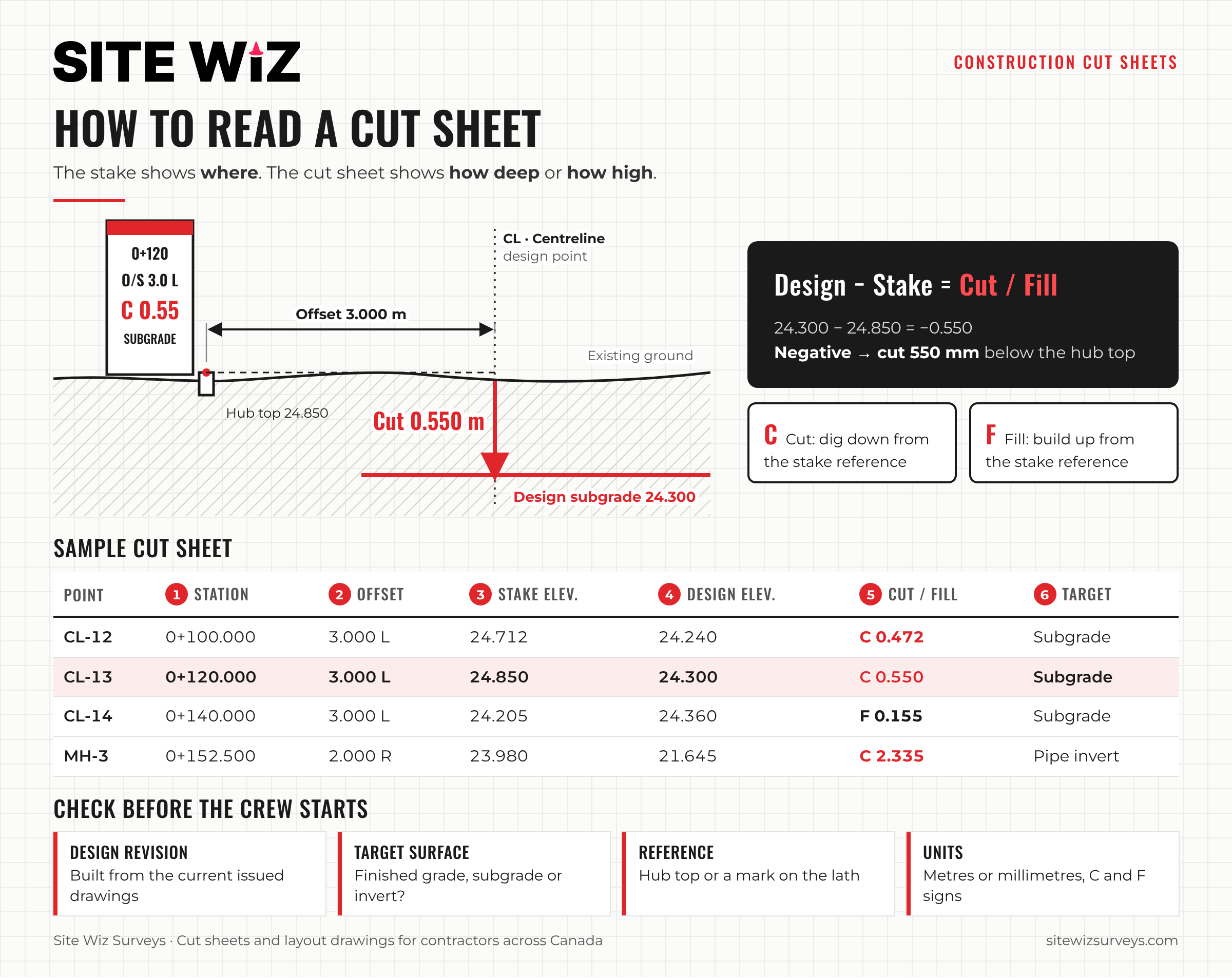
How to Read Cut and Fill on a Survey Stake
Take a simple example. A road stake at station 0+120 is set 3.000 m left of centreline. The top of the hub was measured at 24.850 m. The design subgrade at the centreline point is 24.300 m.
24.300 − 24.850 = −0.550. The result is negative, so the crew must cut 0.550 m (550 mm) below the reference on the stake. On the lath this is usually written as “C 0.55” with “O/S 3.0 L” for the offset, although each firm has its own convention.
If the design were 25.100 m instead, the result would be +0.250: a fill of 250 mm, written “F 0.25”.
Common markings you will see
- C / F: cut or fill, followed by the value in metres or millimetres.
- O/S: offset distance to the design point.
- CL, EP, BC, TC: centreline, edge of pavement, back of curb, top of curb.
- INV: pipe invert, the inside bottom of the pipe.
- Grade mark: a line on the lath set at a convenient height and used as the reference instead of the hub top.
Because conventions differ, the first step on any new job is to confirm with the survey team how values are written and which reference they are measured from. For a wider look at how stakes are placed, see our guide to survey staking in civil construction.
Cut Sheets for Different Types of Civil Work
Roads and parking areas
Road cut sheets usually list points along the centreline and edges at regular stations, plus curb returns and catch basins. Values often target subgrade or the top of a granular layer, so the paving crew is not chasing grades later. Our article on surveys for road construction in BC covers the full road sequence.
Storm, sanitary and water lines
Pipe cut sheets give the invert elevation at each manhole and at intervals between them, with the cut measured from an offset stake down to the invert. Crews use them with a pipe laser or grade rod to set pipe on the design slope. See also our guide to utility construction layout.
Building pads and foundations
For structures, cut sheets list corners, gridline offsets and top-of-footing or top-of-slab elevations. Small errors show up quickly in formwork, so values are usually given to the millimetre.
Mass earthworks
On bulk grading, cut sheets are often supported or replaced by 3D surfaces loaded into machine control. Even then, a set of checked grade stakes with a cut sheet is a simple way to confirm the machines are building the right surface. Learn more about 3D machine control modelling.
Five Checks Before a Crew Starts Work
- Design revision. The sheet should name the drawing set and revision it was built from. If a newer revision has been issued, the cut sheet must be updated before work continues.
- Target surface. Confirm whether values are to finished grade, subgrade, invert or another surface, and that the crew knows the layer thicknesses.
- Reference point. Confirm whether values are measured from the hub top, a nail or a grade mark on the lath.
- Units and signs. Check metres versus millimetres and how cut and fill are shown.
- Spot check. Before excavation, check a few stakes against site control to confirm nothing has been disturbed.
These checks take minutes. Skipping them is how a correct layout can still produce a wrong grade.
Common Cut Sheet Mistakes and How to Avoid Them
- Working from an outdated design. The most frequent problem. Keep one controlled set of drawings and date every cut sheet.
- Mixing up the target surface. A cut to finished grade used as a cut to subgrade leaves the structural layers too thin.
- Disturbed stakes. A stake bumped by equipment gives a wrong reference. Re-check suspect stakes before relying on them.
- Cluttered formatting. Sheets crammed with extra columns are hard to read on a tailgate. Give the crew what it needs and keep the rest in the office file.
- No link to the project record. File cut sheets with the layout data so they can support as-built record drawings and answer later questions.
How Site Wiz Prepares Cut Sheets
At Site Wiz, cut sheets are part of our drafting services. We build them from the current design files, check them against the design and the control used on site, and format them so crews can read them quickly in the field. Because this work is done in the office, we prepare cut sheets and layout drawings for contractors anywhere in Canada, using your design files and survey data.
On projects in Victoria, on Vancouver Island and across BC, our field team can also complete the construction layout itself, so the stakes in the ground and the numbers on the sheet come from one source.
Need cut sheets for an upcoming project? Contact Site Wiz with your drawings and schedule, and we will tell you what we need to get started.
Frequently Asked Questions
What is the difference between a cut sheet and a grade sheet?
The terms are often used for the same document: a table of staked points with the cut or fill to design. Some firms use “grade sheet” mainly for pipe and road grades and “cut sheet” more broadly.
Is cut or fill measured from the existing ground?
No. It is measured from the reference on the survey stake, usually the top of the hub or a mark on the lath, to the design surface. The ground next to the stake may be higher or lower.
Can cut sheets be prepared remotely?
Yes. When the design files and the staked point data are available, cut sheets can be prepared in the office. Site Wiz does this for contractors across Canada.
How often should cut sheets be updated?
Whenever the design is revised or stakes are re-set. Each sheet should show its date and the drawing revision it is based on.
Does Site Wiz complete legal or property boundary surveys?
No. Site Wiz provides construction surveying services. Legal and property boundary surveys in BC must be completed by a BC Land Surveyor.