A single centimetre of deviation on a digital blueprint can translate into hundreds of thousands of dollars in rework once the excavators begin to move. In the high-stakes environment of heavy civil projects, the margin for error is very small. You likely recognize the frustration of discovering a misaligned utility line or an inefficient grading pass that forces a crew to backtrack. These setbacks don’t just impact the schedule; they erode the profitability and trust that define a successful build.
Professional survey staking civil construction acts as the critical data bridge between static engineering designs and the physical reality of the site. This guide will show you how to leverage precision layout to ensure project elements are placed with accuracy. We’ll explore how modern staking techniques optimize machine grading efficiency and help maintain a clear, verifiable record for progress payments. By treating the survey process as a strategic partnership, you can transform complex technical requirements into a smooth, predictable delivery.
Key Takeaways
- Understand how professional survey staking civil construction differs from legal boundary work and why this technical distinction is vital for site liability.
- Learn how Robotic Total Stations and advanced GPS systems provide the centimetre-level accuracy required for complex infrastructure and utility alignment.
- Discover how professional layout prevents the significant financial losses associated with manual grading errors and project rework.
- Explore the integration of 3D surface modelling and machine control to streamline earthmoving operations and accelerate overall project delivery.
- Realize the importance of maintaining accurate as-built records to facilitate faster inspections and secure timely progress payments from stakeholders.
What is Survey Staking in Civil Construction?
Survey staking in civil construction represents the critical transition point where a conceptual design becomes a physical reality. It’s the methodical process of interpreting complex engineering plans and physically marking the site with stakes, pins, or paint to guide the construction crew. While some view it as a simple field task, it’s actually a sophisticated data management exercise. It ensures that every curb, pipe, and foundation sits exactly where the engineer intended.
A common point of confusion in the industry is the difference between legal boundary surveying and construction layout. Legal surveying defines property lines and ownership limits, which is a specialized legal function. In contrast, survey staking civil construction focuses entirely on the spatial positioning of new infrastructure within those established boundaries. By treating the surveyor as a strategic consultant rather than just a field technician, developers and engineers can identify potential design conflicts before the first shovel hits the ground. It’s the first physical step in any infrastructure project, providing the reliable framework that all subsequent work depends on.
The Purpose of Construction Layout
The primary objective of construction layout is the precise translation of 2D engineering blueprints into 3D physical coordinates. This isn’t just about horizontal placement; it’s about establishing the vertical elevations that govern drainage and structural integrity. A professional layout service provides several essential benefits:
- Establishing Control Networks: We create a reliable grid of permanent benchmarks that all subsequent trades use to maintain consistency across the entire site.
- Ensuring Design Compliance: Accurate staking ensures the project meets strict regulatory requirements and stays within specified design tolerances.
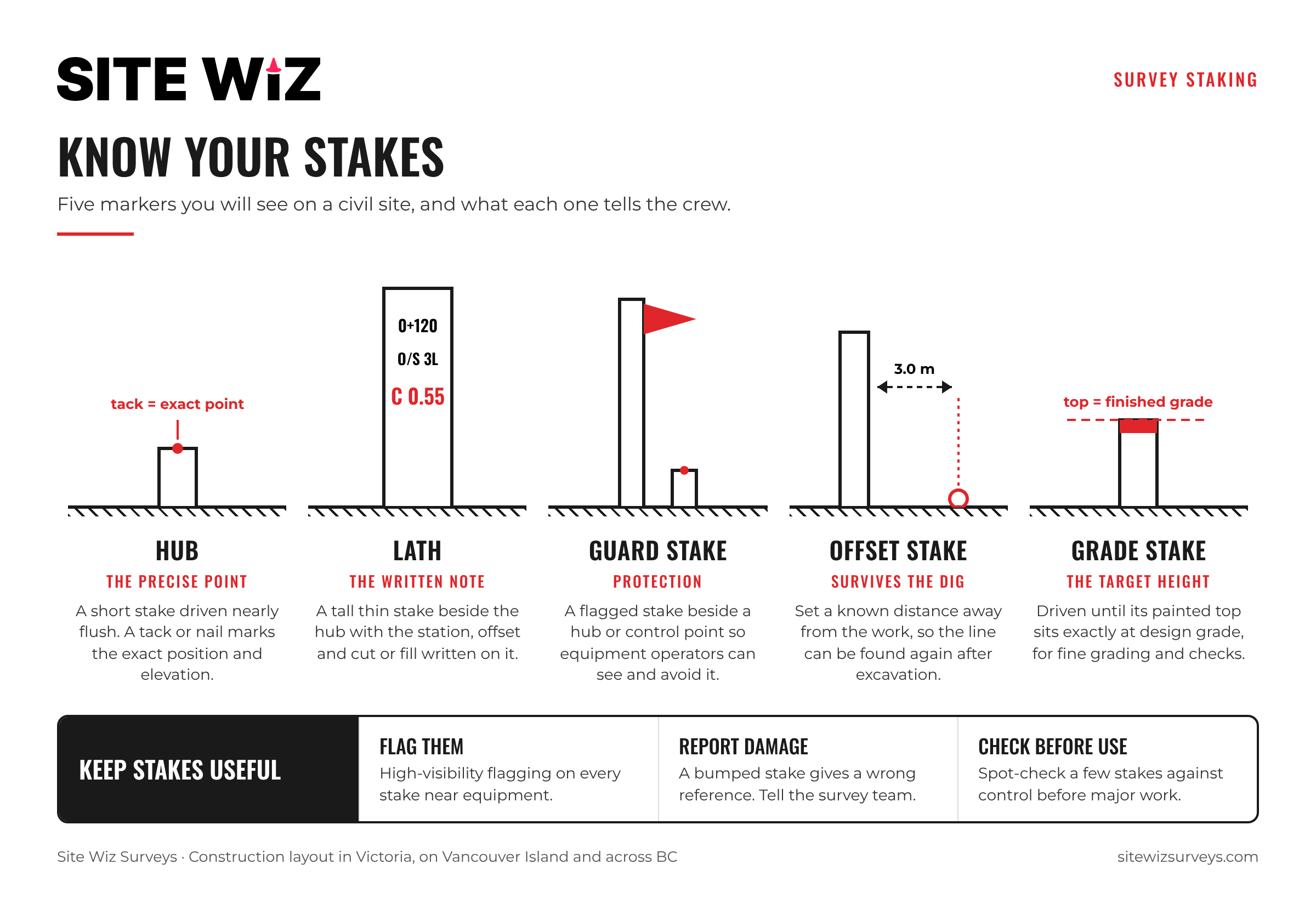
- Facilitating Communication: Clear markings act as a universal language for excavators, pipe layers, and concrete crews, reducing the need for constant plan interpretation.
Key Elements Marked During Staking
During the lifecycle of a project, various elements require specific marking to keep operations moving efficiently. These markings evolve as the project moves from initial clearing to final paving.
- Infrastructure Alignment: We mark the horizontal and vertical paths for roads, bridges, and underground utilities to prevent costly overlaps or misalignments.
- Grading Indicators: Staking provides rough grade and finish grade markers, which are essential for earthmoving crews to achieve the correct site drainage.
- Structural Footprints: Precise layout of foundations and retaining walls ensures that structures are oriented correctly and sit on stable, engineered ground.
The Science and Technology Behind Modern Staking
The days of relying solely on transit levels and manual tape measurements have largely faded into the history of the industry. Modern survey staking civil construction relies on a sophisticated digital ecosystem where field hardware and office software operate in a continuous loop. Robotic Total Stations (RTS) have changed field work by allowing a single operator to achieve centimetre-level positioning through automated prism tracking. These units use a high-frequency laser to measure angles and distances, creating a real-time feedback loop that reduces much of the human error associated with traditional methods. While RTS handles high-precision structural layout, Global Positioning Systems (GPS) provide the necessary wide-area control for large-scale earthmoving and utility corridors.
From 2D Plans to 3D Data Files
Engineers often deliver designs in 2D formats, such as PDFs or flat CAD files, which lack the depth required for modern autonomous machinery. The professional surveyor’s role involves carefully converting these designs into a comprehensive Triangular Irregular Network (TIN). This digital surface model represents the terrain as a series of contiguous, non-overlapping triangles, allowing for precise volume calculations and real-time grade checking. Standardizing these data formats ensures that whether a crew uses a bulldozer or an excavator, the digital instructions remain consistent across all equipment platforms. It’s this transition from paper to a 3D environment that enables the high-speed efficiency of modern civil projects.
Establishing Site Control Networks
A project’s spatial integrity doesn’t just happen by accident. Establishing a robust primary control network is the fundamental step that ensures every phase of survey staking civil construction remains consistent over time. We differentiate between local engineering grids, which might be specific to a bridge or building footprint, and global coordinate systems like UTM. Maintaining these control points is vital; if a primary marker is disturbed by heavy machinery, the entire site’s alignment is at risk. Ensuring your site has a professional Control Network Establishment at the outset provides the stability needed for complex, long-term infrastructure delivery. This reliable backbone allows different crews to work on separate sections of a site while knowing their work will meet in the centre.
Maximizing ROI: Reducing Rework and Improving Efficiency
The financial success of an infrastructure project is often determined by what doesn’t happen: no utility strikes, no grade failures, and no expensive removals of incorrectly placed concrete. Precision survey staking civil construction is the most cost-effective insurance policy a contractor can hold. When layout is handled carefully, it facilitates faster project approvals and municipal inspections, as officials can trust that the work matches the permitted plans. Errors in the field often create a ripple effect, where one misplaced stake leads to a week of idle machines and wasted labour. Avoiding these scenarios is essential for maintaining the quiet confidence that a project is on track and within budget.
A strategic approach to construction layout to reduce rework involves identifying discrepancies between the design and the actual site conditions before construction begins. By using as-built record drawings to verify installations before backfilling, you create a permanent, accurate record that protects against future liability and simplifies maintenance. This proactive verification means you won’t have to excavate a finished road just to find a misaligned manhole or a shallow water main.
Avoiding Costly Utility Strikes and Misalignments
In complex urban environments, the margin for error when installing deep utilities is often measured in millimetres. Misplacing a gravity-fed sewer line by even a fraction of a percent in slope can lead to system failures and total reconstruction. Professional survey staking civil construction ensures that invert elevations and horizontal alignments are verified against existing infrastructure, preventing the nightmare of utility conflicts that halt production for weeks. We provide the precise positioning required to navigate the subterranean “spaghetti” of existing pipes and cables that often differ from original site plans.
Streamlining Earthwork and Material Management
Earthmoving is one of the most significant expenses in civil construction. Staking provides the precise boundaries for cut-and-fill operations, ensuring that crews don’t move more dirt than necessary. This accuracy directly supports volumetric calculations and quantity take-offs, which are essential for securing accurate progress payments from owners. By maintaining tighter grading tolerances, you significantly reduce material waste and optimize the use of heavy equipment. To protect your project’s margins and ensure every cubic metre of soil is accounted for, consider partnering with a specialist for your Construction Layout needs.
The Future of Staking: 3D Machine Control Integration
Civil construction is currently undergoing a significant technological shift. While traditional wood stakes have guided crews for decades, the industry is increasingly moving toward digital staking through 3D machine control. This evolution doesn’t replace the surveyor; instead, it elevates their role to that of a high-level data architect. By integrating GPS-guided machinery directly with digital design files, contractors can achieve a level of grading speed and precision that was previously impossible. Site Wiz Surveys supports this transition by providing the advanced data preparation and 3D surface modelling necessary to keep heavy equipment moving without interruption. This ensures that the transition to modern methods is handled with the same care as traditional layout.
Implementing 3D Machine Grade Control
Transitioning to an automated site requires a methodical three-step process to ensure the digital model matches the physical earth. First, we convert 2D engineering designs into high-accuracy 3D models that the machine’s onboard computer can interpret. Second, we calibrate the machinery on-site to the established control network, ensuring the GPS coordinates align closely with the local benchmarks. Finally, we perform continuous monitoring and validation of the machine-guided results to confirm that the finished grade meets the design specifications. This structured workflow ensures that survey staking civil construction remains accurate even when the stakes are invisible bits of digital data.
The Hybrid Approach: Staking and Digital Models
Despite the rise of automation, physical construction layout services remain a necessary validation for automated systems. Critical structures, such as bridge abutments or complex building foundations, often require the redundancy of a physical pin to ensure compliance. Balancing automated grading with traditional survey verification creates a fail-safe environment where digital speed meets physical certainty. Looking ahead, the integration of augmented reality and autonomous equipment will further refine how we interact with site data. However, the fundamental need for a professional surveyor to manage the control network and validate the outputs will remain the backbone of every successful project. By combining the latest technological advancements with grounded field experience, we ensure that survey staking civil construction continues to provide the precision your project demands.
Securing the Physical Integrity of Your Infrastructure
The transition from a digital design to a physical asset requires a methodical approach to data management and field execution. Prioritizing professional survey staking civil construction moves your operation beyond simple layout into a strategic process that protects your project from costly misalignments and utility conflicts. Whether you’re utilizing traditional staking or advanced 3D machine control, the goal remains the same: precision from the first grade pass to the final as-built record.
With over 20 years of industry experience, Site Wiz Surveys specializes in providing the high-accuracy 3D data and volumetric reporting that modern civil projects demand. Our team acts as a reliable backbone for your operations, ensuring your machinery is calibrated and your project elements are positioned with consistent accuracy. Optimize your next project with Site Wiz Surveys’ precision staking and 3D modelling services. We look forward to partnering with you to ensure your next infrastructure delivery is smooth and successful.
Frequently Asked Questions
What is the difference between a land survey and a construction survey?
Land surveys establish legal property boundaries and ownership limits, whereas construction surveys focus on the spatial positioning of new infrastructure. While a land survey is a legal document used for property titles, survey staking civil construction serves as a technical guide for builders. It ensures that roads, pipes, and foundations are built exactly as designed within those established legal limits.
How often should a civil construction site be re-staked?
Re-staking frequency depends on the project’s complexity and the preservation of existing markers. You’ll typically require new stakes when transitioning between project phases, such as moving from rough grading to utility installation. It’s also necessary if heavy machinery or weather conditions displace the original markers. Routine checks of the control network help determine if a site needs a refresh to maintain accuracy.
Can GPS replace the need for physical survey stakes on a project?
GPS and 3D machine control can significantly reduce the number of physical stakes, but they don’t reduce the need for them entirely. Automated systems allow operators to see digital “stakes” on a screen, yet physical markers remain essential for manual checks and for trades that don’t use GPS-guided equipment. We recommend a hybrid approach where physical layout validates the digital model for critical structural elements.
What information is typically written on a construction survey stake?
Construction stakes typically display the station number, the offset distance from the design line, and the specific cut or fill vertical requirement. They’ll also include a label identifying the feature, such as “Sanitary Sewer” or “Top of Curb.” These shorthand notations allow equipment operators and labourers to understand exactly how much earth needs to be moved or where a structure begins without referencing a paper plan.
Who is responsible for maintaining the survey stakes once they are driven?
The general contractor or site superintendent is responsible for protecting and maintaining survey stakes once they’ve been placed by the surveyor. If a crew accidentally knocks over a stake, it shouldn’t be replaced manually, as this introduces significant error. Instead, the surveyor should be called to reset the point using the established control network to ensure the project’s spatial integrity isn’t compromised.
How does survey staking help with quantity take-offs and progress payments?
Professional survey staking civil construction provides the precise data needed for volumetric calculations and as-built reporting. By recording the exact elevations and coordinates of installed elements, we can verify the quantity of material moved or pipe laid. This objective record allows contractors to justify progress payments and provides owners with confidence that they’re paying for work that meets the design specifications.