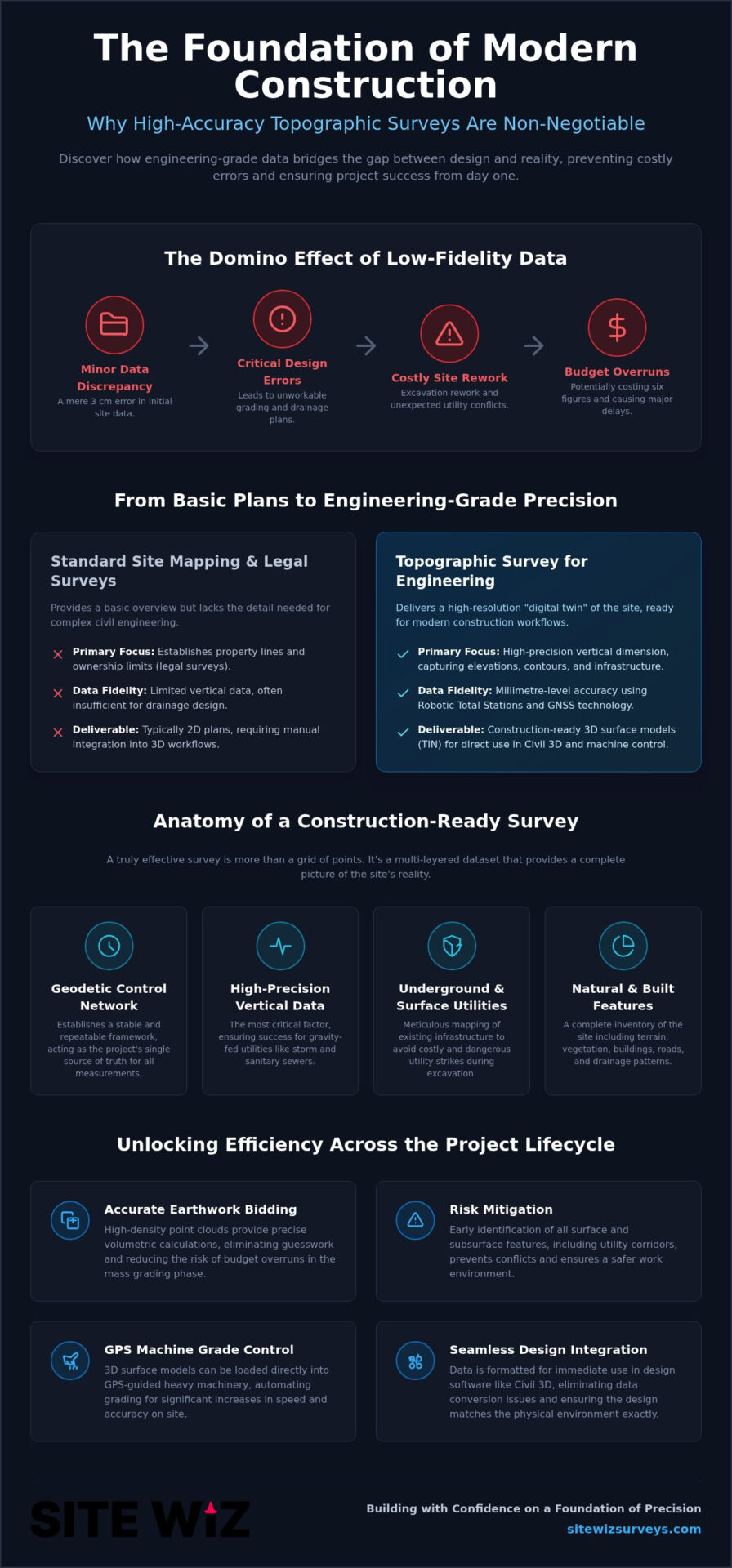
Could a three-centimetre discrepancy in your initial site data lead to a six-figure budget overrun during the excavation phase? It’s a question that keeps many project managers awake, as design errors caused by low-fidelity data often result in costly rework and site delays. You likely recognize that a project is only as reliable as its baseline measurements, yet integrating traditional 2D plans into modern 3D workflows remains a persistent challenge for many civil teams. Securing a professional topographic survey Victoria BC is the most effective way to bridge this gap and ensure your site data is construction-ready from day one.
In this guide, you will discover how high-accuracy topographic surveys provide the essential 3D foundation for successful civil engineering and construction projects. We will examine how a high-fidelity surface model, ready for Civil 3D, reduces the risk of utility conflicts and provides the precise volumetric data you need for accurate earthwork bidding. By moving beyond basic mapping and embracing a digital-twin approach, you can realize greater efficiency and confidence throughout the entire project lifecycle.
Key Takeaways
- Understand why high-precision vertical data is the critical factor that distinguishes engineering-grade surveys from basic site mapping.
- Learn how a professional topographic survey Victoria BC provides the 3D foundation necessary to prevent design errors and mitigate the risk of costly excavation rework.
- Discover how 3D surface modelling enables GPS machine grade control, significantly increasing efficiency and reducing the need for manual grade checking on site.
- Identify the essential data layers required to manage gravity-fed utility systems and ensure seamless integration with modern civil design software.
- Evaluate the technical criteria for selecting a surveying partner, focusing on the use of robotic total stations and the ability to deliver construction-ready data.
What is a Topographic Survey for Site Development?
A topographic survey is essentially a high-resolution snapshot of the physical reality on the ground. While a Topographic map usually refers to broad geographic representations, site-specific surveying for development requires a much tighter focus. It involves the meticulous mapping of both natural and man-made features on a parcel of land. Many developers often confuse these with legal boundary surveys; however, the two serve very different functions. A legal survey establishes property lines and ownership limits, whereas a topographic survey Victoria BC focuses on the vertical dimension, capturing elevations, contours, and existing infrastructure. This data acts as the critical base layer upon which every civil engineering or architectural design is built. Without it, designers are essentially working in the dark regarding the actual slope and drainage characteristics of the land.
Modern site data collection has evolved far beyond traditional manual methods. Today, professional surveyors utilize robotic total stations and GNSS (Global Navigation Satellite System) technology to capture thousands of distinct data points. This level of precision allows for millimetre-level accuracy, ensuring that the digital representation of the site matches the physical environment exactly. Much of this consistency comes down to how the GNSS corrections themselves are delivered; our explanation of why NTRIP-delivered RTK corrections outperform traditional base and rover setups covers why this matters even on a single topographic site with varied terrain and tree cover. This precision is not just for show; it’s a fundamental requirement for modern construction workflows that rely on digital data for everything from volume calculations to machine guidance. By establishing a reliable control network, surveyors ensure that every measurement taken on-site is consistent and repeatable throughout the project’s duration.
The Primary Purpose of Topographic Mapping
The ultimate goal of this process is to facilitate accurate site grading and drainage design. In Victoria’s varied terrain, understanding how water will move across a site is vital to preventing future flooding issues. Additionally, identifying existing utility corridors early in the process is essential. Accurate mapping of these underground and surface assets helps project managers avoid costly utility strikes during the excavation phase. Providing a high-fidelity topographic survey for engineers allows them to realize complex designs that respect the site’s unique constraints while maximizing buildable area.
Key Deliverables: From 2D Plans to 3D Models
The outputs of a modern survey are as varied as the projects they support. While traditional 2D CAD drawings remain a staple for showing contours and planimetric features, the industry is shifting toward more sophisticated deliverables. High-fidelity 3D surface models, often in the form of a Triangulated Irregular Network (TIN), are now standard for engineering-grade projects. These models are designed for immediate integration into design software like Civil 3D. Digital files can also be formatted for use with GPS-guided heavy machinery, allowing for automated grading that significantly increases on-site efficiency and reduces the need for manual grade checking.
Essential Data Layers in a Professional Site Survey
A professional topographic survey Victoria BC must provide more than a simple grid of ground elevations. To be truly construction-ready, the dataset needs to encompass multiple layers of information that reflect the buildable reality of the site. This process begins with establishing a primary geodetic control network. This network acts as the anchor for every subsequent phase, from the initial excavation to the final as-built record drawings. Without this stable framework, discrepancies can creep into the data, leading to misalignments between the design and the physical execution. Reliability in the field starts with this fundamental level of precision, which is why a thorough control network establishment survey is the critical first step before any topographic data collection begins.
Vertical accuracy is the most critical factor in these datasets. While horizontal positioning is important, the vertical component dictates the success of gravity-fed utility systems, such as sanitary and storm sewers. A minor error in elevation can render an entire drainage plan unworkable. High-accuracy data also allows for precise volumetric calculations. By capturing a high density of points in rugged or irregular terrain, surveyors provide contractors with the exact figures they need for earthwork bidding. This methodical approach significantly reduces the risk of budget overruns during the mass grading phase.
Natural and Built Environment Features
A comprehensive survey captures the nuances of the landscape that impact environmental compliance and design constraints. This includes the precise location of significant vegetation and tree driplines, which are often protected by local bylaws. Beyond the natural, we document existing structures, retaining walls, and neighbouring building footprints to ensure new construction respects setback requirements. We also capture the fine details of the local infrastructure, including road centrelines, curbs, sidewalks, and accessible pathways. These details are essential for ensuring that new site access points integrate seamlessly with the existing municipal fabric.
Utility and Infrastructure Identification
Success on a complex job site depends on a holistic view of the existing infrastructure. This involves identifying all surface evidence of underground utilities, such as manholes, valves, and hydro vaults. However, the true value lies in the measurement of invert elevations. Knowing the exact depth and slope of existing pipes is the only way to confirm that new connections are mathematically viable before the first shovel hits the ground. When selecting a Professional Surveying Partner in Western Canada, it is important to ensure they can integrate utility locate data directly onto the topographic base map. This unified data layer provides a clear roadmap for the excavation team and helps eliminate the guesswork that often leads to utility strikes during a topographic survey Victoria BC.
Engineering-Grade Data vs. Standard Land Surveys
Why do developers frequently find themselves facing unexpected site challenges after the design phase is complete? It’s often because they realize too late that a legal boundary survey, while necessary for land titles, doesn’t provide the high-fidelity data required for construction. A legal survey defines ownership limits and property corners, but it rarely captures the buildable reality of the terrain. To build with confidence, you need an engineering-grade topographic survey Victoria BC that prioritizes the physical characteristics of the site over mere legal descriptions. This distinction is the difference between a design that works on paper and one that’s ready for the excavator’s bucket.
Meticulous detail in the preliminary phase acts as a safeguard against expensive change orders. When site data is sparse, engineers are forced to make assumptions about slopes, drainage, and existing infrastructure. If those assumptions are proven wrong once machines are on site, the resulting delays can be devastating to a project’s timeline. A professional surveying firm bridges the gap between the architect’s vision and the contractor’s execution by providing a digital twin of the environment. This ensures that every design element is grounded in physical fact, allowing for a seamless transition from the drawing board to the field.
The Limitations of Basic Topographic Mapping
Standard topographic maps often lack the point density required for high-accuracy volumetric earthwork calculations. If points are taken too far apart, the resulting surface model misses subtle but significant terrain changes. Another common oversight is the omission of breaklines. These are the lines that represent sharp changes in slope, such as the top of a retaining wall or the flow line of a gutter. Without these, CAD software creates a smoothed, inaccurate surface. Additionally, a lack of geodetic control can cause significant alignment issues when transitioning to construction layout services Victoria BC, leading to costly errors in building placement.
Why Precision Staking Requires a Strong Topo Foundation
Precision staking is only as reliable as the survey data that precedes it. We focus on ensuring that the digital design perfectly matches the physical site conditions before the first stake is ever driven. By identifying potential design conflicts in a virtual 3D environment first, we significantly reduce the risk of rework during the active construction phase. This process relies on establishing permanent benchmarks that remain stable throughout the multi-year lifecycle of a project. These reliable control points serve as the backbone for all future measurements, ensuring consistency from the initial topographic survey Victoria BC through to the final as-built inspection.
Leveraging 3D Surface Modelling for Machine Control
How does a static site map transform into an active tool for heavy equipment? The answer lies in the transition from raw data to a functional digital twin. A high-accuracy topographic survey Victoria BC provides the essential raw material needed to construct 3D machine control models. These models act as the digital intelligence for excavators, dozers, and graders, allowing operators to see the design surface in real-time on their onboard displays. By utilizing this technology, contractors can automate much of the grading process, which significantly reduces the need for manual grade checking and minimizes the risk of human error during the mass excavation phase.
Converting 2D engineering plans into high-accuracy 3D survey data is a specialized skill set that requires both technical expertise and field experience. It’s not enough to simply trace lines; the modeller must understand the nuances of civil design to ensure the digital surface is truly “buildable.” This process involves establishing a seamless data flow between the surveyor, the design engineer, and the equipment operator. When this workflow is optimized, the result is a project that moves faster, stays on grade, and avoids the costly “over-digging” that often plagues projects relying on traditional staking alone.
From Field Data to GPS-Guided Machinery
The core of this technology is the creation of a Triangulated Irregular Network (TIN). This is a sophisticated 3D surface that heavy equipment can interpret via onboard GPS receivers. For civil infrastructure projects, maintaining strict vertical tolerances is paramount, particularly when preparing the fine-grading for sub-base and asphalt layers. Our approach ensures that the digital model provided to the machines is as precise as the initial topographic survey Victoria BC, allowing for a level of finish that meets the most demanding engineering specifications.
Optimizing Earthworks and Volumetrics
Beyond guiding the blades of a dozer, accurate 3D data allows for real-time volumetric tracking of cut and fill operations. Project managers can use this data to calculate precise stockpile volumes for better material management and logistics. As the project nears completion, we generate “as-built” surfaces to verify that the final grade matches the design intent exactly. This data is also necessary for producing as-built record drawings BC, providing a permanent digital record of the completed work for municipal approval and future site maintenance.
If you are looking to increase site efficiency and reduce material waste, our team can help you implement a robust data strategy. Explore our specialized 3D surface modeling services to see how we can support your next project.
Selecting a Professional Surveying Partner in Western Canada
Selecting the right partner for a topographic survey Victoria BC is a decision that impacts every subsequent phase of your development. It’s not merely a matter of equipment; it’s about the expertise required to interpret complex terrain and translate it into a digital format that engineers and contractors can use without hesitation. A firm with specialized experience in civil infrastructure understands that site data isn’t just a map. It’s a liability-reducing asset. By prioritizing partners who utilize robotic total stations and the latest CAD software, you ensure that the integrity of your data remains intact from the initial field shot to the final design model.
Experience across multiple provinces, particularly British Columbia and Alberta, provides a surveyor with a broader perspective on regulatory standards and technical challenges. This multi-jurisdictional familiarity ensures that your project complies with diverse requirements while benefiting from best practices honed in varied environments. Ultimately, the value of a professional surveying partner lies in their ability to reduce project risk and optimize field efficiency. This proactive approach prevents the costly errors that arise from low-fidelity data or misunderstood site constraints.
Technical Capabilities to Look For
When you evaluate potential partners, look beyond the basic deliverables. A high-tier firm should possess the ability to provide sophisticated 3D surface modelling and data preparation specifically for machine control. They must have a proven track record in establishing robust geodetic control networks, especially on complex sites where precision is non-negotiable. It’s also beneficial to work with a team that has the capacity to handle both the preliminary topographic mapping and the subsequent construction layout. This continuity ensures that the project’s baseline data is maintained consistently throughout the entire build, from the first survey to the final as-built record drawings.
The Site Wiz Surveys Commitment
At Site Wiz Surveys, we leverage over 20 years of industry expertise to deliver the meticulous data that engineers trust. Our focus is on providing a high-accuracy foundation for the most demanding civil projects in Western Canada. We don’t view ourselves as just a service provider; we function as a dedicated partner invested in your success. This collaborative approach ensures that your project goals are met on time and on budget, with technical requirements handled with quiet confidence. By focusing on construction-ready data, we provide the specialized support that modern civil contractors and developers require to build with absolute certainty.
Building a Foundation for Construction Success
Precision in the preliminary phase isn’t just a technical requirement; it’s a strategic advantage that protects your project’s budget and timeline. By moving beyond basic mapping and investing in an engineering-grade topographic survey Victoria BC, you eliminate the guesswork that leads to design errors and field rework. We’ve examined how high-density data and 3D surface modelling empower your team to utilize GPS-guided machinery and manage earthworks with absolute certainty.
With over 20 years of civil surveying expertise, Site Wiz Surveys specializes in delivering construction-ready data for BC and Alberta’s leading developers. As specialists in 3D machine control modelling, we bridge the gap between complex engineering designs and physical execution. Our commitment is to provide the reliable backbone your project needs to stay on schedule. Request a Precision Topographic Survey Consultation to ensure your next site is built on a foundation of accuracy and technical excellence. We look forward to partnering with you on your next development.
Frequently Asked Questions
What is included in a standard topographic survey?
A standard survey captures all physical features and vertical elevations on a site to create a detailed digital map. This typically includes ground contours, spot elevations, existing structures, roads, and visible utility infrastructure such as manholes or valves. For a comprehensive topographic survey Victoria BC, we also document significant vegetation and tree driplines to ensure compliance with local municipal environmental bylaws.
How much does a topographic survey cost for a development site?
Costs for a site survey depend on the size of the parcel, the density of the vegetation, and the overall complexity of the terrain. A small residential lot requires fewer resources than a large industrial development with significant grade changes or heavy brush. We recommend providing a clear site plan to receive a tailored estimate that reflects the specific technical requirements and data density your project demands.
Do I need a legal boundary survey or a topographic survey for my project?
You usually need both, but they serve distinct purposes throughout the development lifecycle. A legal survey defines property boundaries and ownership limits, which is required for land titles and setback verification. A topographic survey provides the 3D data needed for engineering design and construction. If you’re planning to build, grade the site, or install utilities, the topographic data is the essential foundation for those designs.
How long does it typically take to complete a site survey?
Completion times vary based on site conditions and the specific scope of the work. Field data collection for an average development site typically takes one to three days depending on the accessibility of the terrain. Office processing, which includes 3D surface modelling and CAD drafting, usually requires several additional business days. We suggest scheduling your survey early in the design phase to avoid potential bottlenecks in your engineering workflow.
What digital file formats will I receive for my engineering team?
Engineering teams typically receive industry-standard digital files that are ready for immediate use. This includes AutoCAD (.dwg) files containing both 2D and 3D data, as well as high-resolution PDF plans for easy sharing. For teams using Civil 3D, we provide surface models (TIN) and digital terrain models. These formats ensure seamless integration into modern design software and GPS-guided construction equipment.
Can topographic data be used for machine control and automated grading?
High-accuracy topographic data is the primary source for building 3D machine control models. By converting 2D designs into 3D survey data, contractors can automate the grading process on excavators and dozers. This technology improves on-site precision and significantly reduces material waste by ensuring the final grade matches the design intent within very tight vertical tolerances.
Why is geodetic control important for civil construction projects?
Geodetic control provides a stable and consistent coordinate system for the entire lifecycle of a project. It ensures that every measurement, from the initial topographic survey Victoria BC to the final construction layout, remains perfectly aligned. Without a robust control network, different phases of the project may suffer from discrepancies. These errors often lead to costly misalignments that require extensive rework during the build phase. Learn how a professional control network establishment survey creates the single source of truth that prevents these cumulative errors from compounding across your project’s lifecycle.
How often should a topographic survey be updated during a multi-phase project?
Surveys should be updated whenever significant physical changes occur on the site that could impact future work. In multi-phase projects, it’s common to conduct a new survey after mass grading is complete but before fine-grading or utility installation begins. These updates, often referred to as as-built checks, verify that the project is progressing according to the design specifications before the next phase starts.