A topographic survey is not merely a passive reference drawing; it’s the fundamental design tool that dictates the feasibility of every architectural decision that follows. Securing a comprehensive topographic survey for architects before schematic design begins establishes an accurate digital baseline for your entire project. Most design teams know the frustration of inheriting incomplete site data, where unverified spot heights, hidden drainage constraints, and disconnected CAD linework force costly design rework once site excavation starts.
You shouldn’t have to resolve grading clashes or foundation misalignments while machinery is already on site. This guide details how a rigorous topographic survey provides the essential digital foundation for smooth BIM integration, accurate 3D surface modelling, and proactive risk mitigation across your building envelope. We’ll explore the exact data layers to request from your surveyor, crucial vertical datum standards like CGVD2013, and workflows that translate raw field measurements into dependable architectural models.
Key Takeaways
- Understand how three-dimensional terrain data directly guides building orientation, foundation depths, and municipal natural grade compliance before drafting begins.
- Discover the essential site features to specify in a topographic survey for architects, including utility inverts, retaining walls, and tree protection zones.
- Learn how structured CAD drafting and triangular irregular networks (TIN) streamline terrain conversion into volumetric Revit Toposolids without coordination errors.
- Explore why establishing a robust geodetic control network early protects your design integrity throughout downstream civil excavation and construction layout.
Understanding the Strategic Value of Topographic Surveys for Architects
A comprehensive topographic survey for architects translates raw physical terrain into an actionable three-dimensional digital model. While preliminary feasibility studies often rely on regional GIS contours, open-source geospatial data rarely delivers the centimetre-level vertical accuracy required for detailed design. Modern land surveying techniques establish true existing conditions, capturing breaklines, natural grade variations, and physical obstacles across the site. Rather than treating the ground as a uniform plane, field surveying maps exact surface geometry, ensuring design work proceeds from verified reality rather than loose assumptions.
Mitigating Design Risk and Rework
Discrepancies between assumed grades and actual terrain drive substantial project friction, and gaps in early site data are a common source of avoidable rework. When elevation models miss abrupt slope transitions or subtle swales, foundation designs require emergency field adjustments during excavation. Establishing verified spot elevations and surface contours early allows design teams to balance cut-and-fill volumes, protect natural drainage paths, and prevent expensive structural revisions once machinery mobilizes.
Ensuring Regulatory and Zoning Compliance
Securing municipal development and building permits requires strict adherence to local zoning bylaws, particularly building height envelopes calculated from Average Natural Grade (ANG). Investing in an accurate topographic survey for architects provides the baseline ground elevations needed to verify building setbacks, defend design heights, and support detailed site grading plans. It also bridges the gap with civil engineering teams during preliminary planning, ensuring both disciplines design against an identical, georeferenced vertical datum.
Essential Data Points: What Your Site Survey Must Capture
Specifying project deliverables requires moving beyond basic surface relief. A thorough topographic survey for architects captures every physical element governing site access, structural load paths, and civil connections. Built upon standard elevation contour line principles, the survey records critical breaklines along retaining wall tops and bases, natural slope transitions, and neighbouring building overhangs or fence encroachments.
The Distinction Between Topographic and Boundary Data
Physical features define how a design sits on the land, but they don’t determine legal property limits. Under provincial statutes, locating and establishing official property boundaries remains the exclusive domain of a licensed land surveyor. Site Wiz Surveys provides specialized field services in Victoria, across Vancouver Island and throughout British Columbia to capture detailed topography and existing infrastructure, coordinating boundary determinations through licensed partners when legal boundary confirmation is required.
Surface Features and Infrastructure
Site design cannot advance safely without mapping surface assets and their subsurface implications. Essential survey layers include:
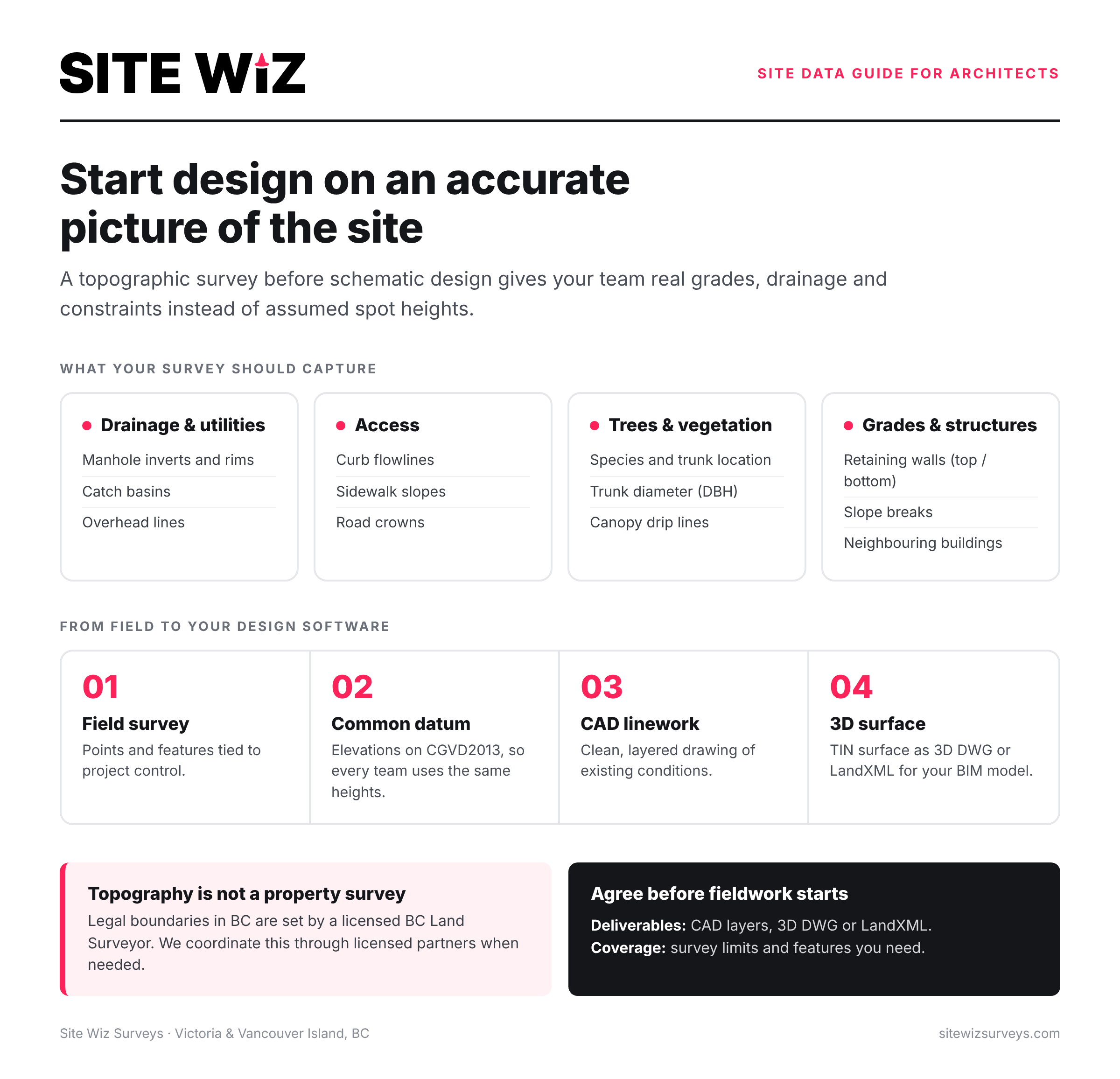
- Drainage and utilities: Invert and rim elevations for manholes, catch basins, utility vaults, and overhead line sag clearances.
- Access geometry: Curb flowlines, sidewalk cross-slopes, and road crowns to ensure municipal access compliance.
- Environmental constraints: Detailed tree inventories, noting species, diameter at breast height (DBH), and canopy drip lines to protect critical root zones during excavation.
If you’re defining the site data scope for an upcoming development, contact our survey specialists to confirm the right feature checklist.
Data Integration: Moving from Field Surveying to CAD and BIM Modelling
Raw point clouds and field coordinates must undergo systematic processing before they become useful design assets. Professional drafting services convert unstructured survey points into clean, layered CAD linework and 3D DWG or LandXML terrain surfaces. Remote data preparation teams can process these raw field datasets for architectural firms across Canada, delivering clean digital terrain models without software translation errors.
Leveraging 3D Modelling for Site Analysis
Generating a Triangular Irregular Network (TIN) bridges the gap between field points and architectural BIM software. In modern platforms like Revit, these surfaces import directly into volumetric tools like Toposolids, enabling precise cut-and-fill calculations, basement excavation volumes, and stepped footing coordination. Treating terrain as an active 3D element lets design teams test site grading scenarios digitally before finalizing foundation schemes.
Accuracy and Tolerance Standards
A successful topographic survey for architects aligns measurement precision with specific project phases. Robotic total stations provide millimetre-level accuracy for structural tie-ins, hardscape edges, and utility connections on tight urban sites. Conversely, drone LiDAR captures broad topography across sprawling acreage efficiently. Specifying the correct sensor workflow ensures adequate detail where structural interfaces demand it without overburdening models with redundant data.
Selecting the Right Survey Partner for Architectural Projects
Commissioning a reliable topographic survey for architects requires choosing a partner who understands architectural workflows and civil site development. Establishing a dependable control network right at project inception provides the permanent spatial backbone for all subsequent construction layout and structural positioning. Working with an experienced survey partner who utilizes robotic total stations alongside modern GNSS/RTK workflows helps capture the grade changes your design depends on. Site Wiz Surveys is led by a founder with over 20 years of hands-on industry experience identifying subtle physical constraints before they compromise your design.
Communication and Deliverable Checklists
Clear scope definition prevents omitted details and expensive remobilization. Before field survey work commences, review critical parameters with your provider:
- Deliverable formats: Confirm required CAD layers, 3D DWG surfaces, or LandXML models to ensure direct compatibility with your design tools.
- Turnaround and milestones: Align field capture dates and data delivery schedules with municipal permit deadlines.
- Datum alignment: Verify geodetic vertical datums to maintain consistency between architectural models and civil grading drawings.
Remote Support Across Canada
While field surveying demands regional presence, digital terrain processing can be delivered anywhere in Canada. Through dedicated remote services, architects across Canada can access high-precision drafting and 3D surface modelling. Processing raw point data into clean, structured digital terrain models gives your team the reliable geometry needed for machine control preparation and smooth BIM integration, regardless of where your project is located.
Advancing Your Site Design with Precision
An architectural concept is only as dependable as the spatial ground data beneath it. Commissioning a detailed topographic survey for architects transforms potential site liabilities into distinct design advantages, reducing the risk of unexpected grading conflicts that trigger costly foundation revisions. From capturing invert depths and tree protection zones to delivering structured CAD surfaces ready for volumetric BIM modelling, verified spatial data protects your project schedule from initial zoning approval through to excavation.
Site Wiz Surveys combines field precision using robotic total stations across British Columbia with specialized remote 3D surface modelling and drafting services for teams across Canada. Supported by over 20 years of hands-on industry experience, we deliver reliable terrain data your firm can design from.
Contact Site Wiz Surveys for a quote on your next topographic project
Let’s ensure your next build starts on solid ground.
Frequently Asked Questions
What is the difference between a topographic survey and a property survey?
A topographic survey captures the physical features, elevations, and three-dimensional contours of the land, providing design geometry for site planning. In contrast, a property survey legally establishes boundary lines, property corners, and easements. Determining legal boundaries is a regulated statutory practice performed by licensed land surveyors. Architectural design relies on a topographic survey for architects to guide foundation and grading design, while boundary surveys establish the legal perimeter where construction can occur.
How much does a topographic survey for a building site typically cost?
Survey pricing depends on site acreage, terrain complexity, vegetation density, and required deliverable details. A small, cleared lot requires fewer field hours than a heavily wooded hillside needing comprehensive tree tracking and breakline definition. Invert measurements on underground utilities and custom 3D surface modelling also influence scope fees. Providing your surveyor with a clear site plan and CAD specification allows them to prepare an accurate, project-specific quote.
Can I use a drone for an architectural topographic survey?
Drones efficiently capture broad ground contours on open, large-scale acreage, but they have distinct operational limitations. Photogrammetry cannot penetrate heavy tree canopies, and aerial sensors cannot measure critical subsurface invert elevations or subtle curb flowlines. For detailed architectural design and structural foundation tie-ins, ground-based robotic total stations and GNSS receivers remain necessary to deliver the millimetre-level precision required for building approvals and accurate BIM integration.
What information does an architect need from a topographic survey?
A complete topographic survey for architects must capture natural ground contours, spot elevations, and critical breaklines along ridges and swales. Essential data layers include utility rims and pipe invert depths, visible services, retaining walls, and finished floor levels of adjacent buildings. Detailed municipal compliance also demands precise tree locations, recording trunk diameters and drip line extents to safeguard critical root zones during foundation planning and site excavation.
How long is a topographic survey valid for an architectural project?
Topographic surveys don’t carry an arbitrary expiry date, but their validity depends on physical site stability. Any intermediate earthmoving, utility trenching, severe seasonal erosion, or tree removal renders previous data obsolete. Most permitting authorities and engineering teams require survey data collected within the last one to two years. If significant site modifications have occurred since the original field visit, ordering an updated survey prevents design discrepancies.