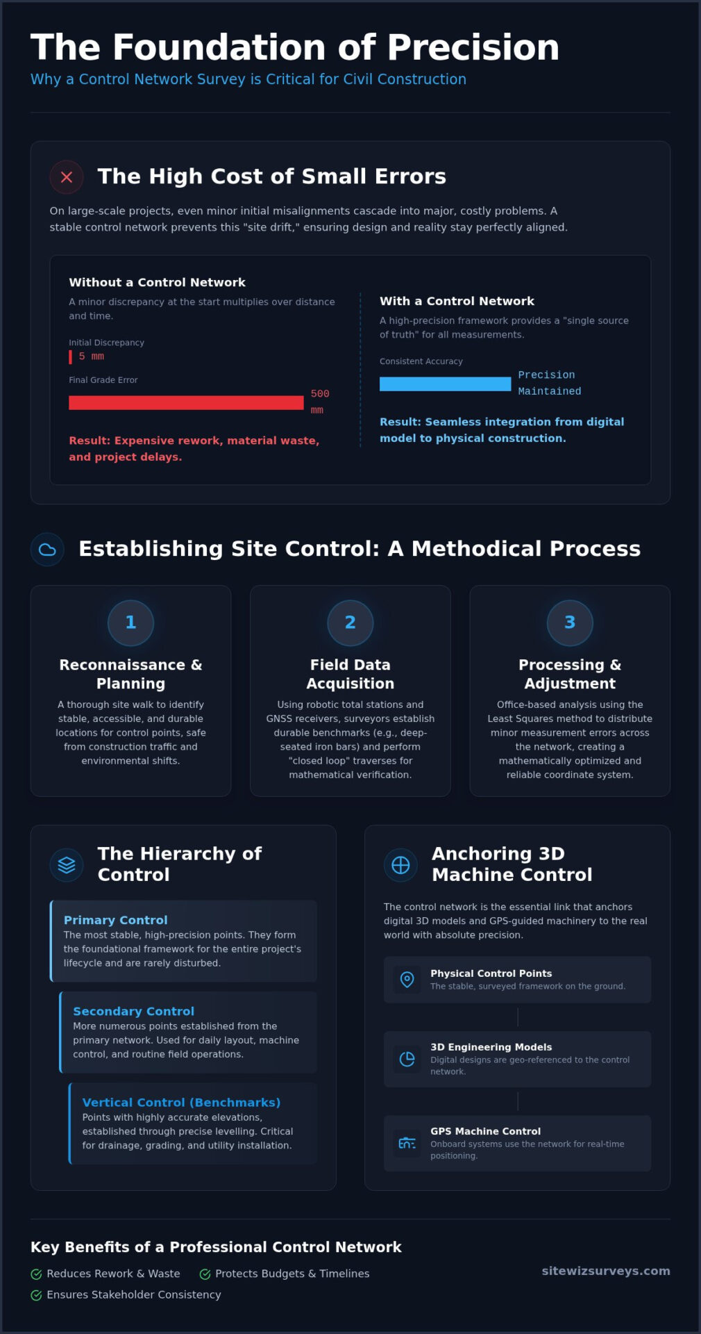
What if a five-millimetre discrepancy at the start of your project turned into a half-metre error by the time you reached the final grade? In large-scale civil construction, even minor misalignments in site data can lead to a cascade of expensive rework and equipment downtime. You likely already recognize that modern 3D modelling and GPS machine control are only as effective as the data anchoring them to the physical world. This is why a professional control network establishment survey is the most critical step in your project’s lifecycle. Without this rigid framework, site measurements begin to drift, causing frustrating gaps between the engineering design and the field reality.
This article explores how establishing a high-accuracy “single source of truth” ensures seamless integration between digital models and physical layout. By prioritizing precision from the outset, you can significantly reduce cumulative errors and protect your bottom line. We will examine the methodical process of creating these networks and why they are the most reliable way to maintain accuracy across complex, large-scale sites.
Key Takeaways
- Understand how a unified coordinate system aligns digital designs with physical site conditions to eliminate costly discrepancies.
- Learn how a meticulous control network establishment survey provides the high-precision backbone required for 3D modelling and automated layout.
- Discover how to manage the hierarchy of primary and secondary control points to support both long-term stability and daily field operations.
- Explore the integration of GNSS technology and robotic total stations to anchor 3D machine control systems with absolute precision.
- Identify the best practices for periodic verification to recognize and replace compromised control points before they impact project timelines.
What is a Control Network Establishment Survey?
A control network establishment survey is the first physical step in transforming a digital design into a real-world structure. It creates a system of permanent, high-precision points that act as the skeletal framework for an entire project. By establishing these points early, we define a unified coordinate system that governs the X, Y, and Z axes across the site. This ensures that every measurement taken, from the first bucket of dirt moved to the final bolt tightened, remains consistent and accurate. A control network is the primary reference framework for all spatial data on a project site.
This work must occur before any topographic mapping or construction layout begins. If you start mapping a site without a rigid control network, you’re essentially building on a foundation of shifting sand. We should also distinguish this service from legal boundary surveying. While legal surveys determine property ownership and property lines, a control network establishment survey is strictly a technical tool for engineering and construction precision. Our expertise lies in the latter, providing the heavy-duty accuracy required for civil infrastructure rather than residential property boundaries.
The Single Source of Truth for Site Data
Consistency is the greatest challenge on large-scale infrastructure projects. Architects, engineers, and contractors often use different software and workflows, but they must all rely on the same spatial data. A professional geodetic control network prevents “site drift,” a common issue where measurements gradually lose alignment as a project moves further from its starting point. By selecting a specific geodetic datum, we ensure the project aligns perfectly with regional standards and existing municipal infrastructure. This creates a “single source of truth” that keeps all stakeholders on the same page, regardless of which phase of the project they’re managing.
Why Precision Matters from Day One
The relationship between control networks and high-accuracy topographic surveys for engineers is fundamental. Topographic data is only as reliable as the points used to collect it. When initial control points aren’t established with meticulous care, errors compound. A three-millimetre shift in a primary control point can result in a fifty-millimetre error during the final paving stage. These discrepancies lead to expensive rework and material waste. Establishing this framework correctly on day one is the most effective way to protect your project’s budget and schedule from the risks of cumulative error.
The Step-by-Step Process of Establishing Site Control
A successful control network establishment survey relies on a methodical journey from physical reconnaissance to mathematical validation. It begins with a thorough site walk to identify locations for control points that are both stable and accessible. These points must survive years of heavy machinery traffic and the freeze-thaw cycles typical of the Canadian climate. We select hardware based on the project’s specific needs, typically deploying a combination of high-precision robotic total stations and multi-frequency GNSS receivers to ensure every measurement is backed by redundant data. If you are unfamiliar with how these instruments differ, our overview of surveying equipment types breaks down how total stations, GNSS receivers, and other field tools each contribute to a precise control network.
Field Procedures and Data Acquisition
Durable benchmarks are the heart of the field phase. We often use deep-seated iron bars or brass caps set in concrete to ensure they don’t shift over time. During data acquisition, we employ traverse surveying with “closed loops.” This technique involves returning to the starting point to measure the mathematical “closure error,” allowing us to identify and correct any minor angular or linear discrepancies. Achieving high vertical accuracy is particularly labour-intensive, as it requires precise differential levelling to establish reliable benchmarks for drainage and grading. The application of GPS in control network surveys has streamlined this process, but it still requires a seasoned professional to manage the nuances of atmospheric interference and signal multipath.
Data Processing and Least Squares Adjustment
Once field data is collected, the work moves to the office for rigorous network adjustment. We use the Least Squares method, which is the industry standard for distributing small, unavoidable measurement errors across the entire network. This process ensures that no single measurement carries an undue amount of error, resulting in a mathematically optimized coordinate system. This rigorous approach to a control network establishment survey ensures that every subsequent measurement is anchored to a verified, stable framework. We then verify that the network meets the specific precision requirements of the project before generating a final control report. This documentation includes coordinate values, metadata, and site sketches, providing a clear roadmap for all future site activities.
If you’re preparing for a major infrastructure project, our team can help you establish a robust control network that serves as your project’s permanent reference.
Primary, Secondary, and Vertical Control: Understanding the Hierarchy
Precision on a civil site isn’t achieved by treating every point with equal weight. Instead, a professional control network establishment survey relies on a rigid hierarchy that dictates how data flows from the most accurate primary points down to the secondary markers used in the field. This tiered structure ensures that errors don’t propagate across the site. By establishing a high-accuracy backbone first, we create a reference system where every subsequent measurement is constrained by the tiers above it.
The hierarchy typically consists of three distinct levels:
- Primary Control: These are the most stable and accurate points on the project, often established using long-duration GNSS observations to anchor the site to a geodetic datum.
- Secondary Control: These points provide the density required for day-to-day construction layout services, allowing crews to work efficiently within smaller zones.
- Vertical Control: A specialized set of benchmarks used exclusively for elevation, ensuring that gravity-fed systems like sewers and storm drains function as designed.
This hierarchical approach is vital because it ensures that secondary points never exceed the error tolerances of the primary network. If a primary point is accurate to within five millimetres, the secondary points derived from it are held to that same rigorous standard, preventing the “stacking” of errors that often plagues unmanaged sites.
Building the Primary Framework
The primary framework establishes the outermost limits of the site with maximum precision. We typically use high-grade GNSS technology to establish these wide-area coordinates, ensuring the project is correctly positioned within the regional coordinate system. It’s essential to locate these primary points in “safe zones,” such as areas outside the limits of clearing and grubbing. This placement ensures the backbone of the survey remains undisturbed by heavy excavation or material stockpiling, providing a reliable reference for the entire project lifecycle.
Vertical Benchmarks and Drainage Precision
Elevation control is often the most demanding aspect of a control network establishment survey, especially for gravity-fed utility systems. There’s a significant technical difference between ellipsoidal heights provided by GPS and the orthometric heights required for physical construction. While GPS measures a mathematical model of the earth, digital levelling accounts for the actual pull of gravity, which is what water follows. Maintaining vertical consistency across multiple kilometres of road construction requires meticulous differential levelling between benchmarks to ensure that every centimetre of slope is accounted for correctly. This level of detail prevents the “flat spots” or back-slopes that can lead to catastrophic drainage failures during heavy Canadian rainfalls.
Integrating Control Networks with 3D Machine Control
Modern civil construction relies heavily on automated grading, but these machines are only as smart as the coordinates they’re fed. A rigid control network establishment survey provides the essential bridge between the digital design and the physical earth. While regional GPS corrections can provide general positioning, they often lack the centimetre-level precision required for tight-tolerance grading. Local control points allow contractors to set up dedicated base stations that transmit high-frequency corrections directly to the machine’s cab, ensuring that every pass of the blade is accurate to the millimetre.
This integration ensures that the 3D surface model used by the equipment aligns perfectly with the physical site stakes. When a dozer operator sees a zero-grade reading on their display, a robust control network guarantees that the physical elevation matches that digital promise. By using local control rather than broad satellite-based corrections, you eliminate the uncertainty that comes with signal latency or atmospheric interference. This level of reliability is what allows projects to move from bulk excavation to final subgrade without the need for constant manual checking.
Site Localization and GPS Calibration
Site localization is the critical process of “teaching” a machine where it is on the local project grid. By measuring established control points with the machine’s GNSS sensors, operators can calibrate their systems to the specific geometry of the site. This step is vital for reducing “vertical float,” a common issue where excavators and dozers lose vertical precision due to weak signal geometry. Professional control networks eliminate the “drift” often seen in uncalibrated GPS systems, ensuring that machine coordinates remain stable throughout the workday. This calibration anchors the digital model to the physical world, making the machine a direct extension of the engineering plans.
Data Preparation for Grade Control
Success in machine control isn’t just about the hardware; it’s about the data. We ensure that the control network data is perfectly synced with the digital surface models before they ever reach the field. Site Wiz Surveys specializes in this technical translation, ensuring data compatibility between the surveyor’s instruments and the heavy equipment’s control box. This meticulous preparation includes verifying as-built record drawings against the original control to catch discrepancies before they become field errors. If your project requires high-precision automation, you can partner with us for 3D model integration to ensure your fleet operates with absolute certainty.
Ensuring Long-Term Stability for Civil Infrastructure
A control network is not a “set and forget” asset. During a multi-year project, the integrity of the initial control network establishment survey can be threatened by various factors, from heavy machinery strikes to natural soil settlement. Maintaining the precision of these points is vital for the continued accuracy of all site activities. If a primary benchmark shifts even a few centimetres due to frost heave or nearby excavation, every measurement derived from it becomes suspect. This is why periodic verification is a non-negotiable part of professional site management.
Identifying “compromised” control points requires a methodical approach to data comparison. By regularly re-measuring the network, we can detect subtle movements before they lead to significant layout errors. When a point is found to be unstable, it must be decommissioned and replaced with a new, verified marker that is tied back into the original primary framework. This ongoing vigilance ensures that the “single source of truth” we established at the project’s outset remains reliable until the final as-built is signed off. Once the project is complete, the final handover of control data provides the owner with a precise coordinate system for future facility management and expansion.
Protecting Your Investment in Accuracy
Physical protection is the first line of defence for your site benchmarks. We recommend surrounding primary points with high-visibility bollards or witness posts to prevent accidental disturbance by equipment operators. Beyond physical barriers, scheduling regular “check-ins” is essential, especially after significant seasonal changes or major earthmoving phases. These checks ensure the network hasn’t shifted due to the massive weight of material stockpiles or changes in the water table. While some may view this as an added labour cost, a cost-benefit analysis quickly reveals that maintaining an existing network is far more economical than performing a full re-survey after a catastrophic layout error occurs.
Choosing a Partner for Control Network Establishment
Experience in civil infrastructure is a critical requirement when selecting a survey firm. The technical demands of a control network establishment survey go far beyond basic measurement; they require a deep understanding of geodetic principles and the harsh realities of a construction environment. Site Wiz Surveys brings over 20 years of specialized experience to every project, functioning as a strategic ally for civil contractors. Our commitment to meticulous data management and the use of advanced robotic total stations ensures that your project’s foundation is built on absolute precision.
Don’t leave your site’s accuracy to chance. Ensure your project starts on solid ground with our professional control network services.
Securing Your Project’s Future Through Precision
A civil project is only as reliable as the coordinates that guide it. By establishing a “single source of truth” through a rigorous hierarchy of primary and secondary points, you eliminate the risk of site drift and cumulative error. These frameworks don’t just provide a map; they provide the mathematical certainty required for modern 3D machine control and automated grading. Investing in a professional control network establishment survey at the outset is the most effective way to protect your budget from the high costs of rework and misalignment.
With over 20 years of civil surveying experience, Site Wiz Surveys specializes in providing meticulous accuracy for complex infrastructure projects. We focus on high-quality 3D data to ensure your GPS-guided machinery operates with absolute confidence. Our team acts as a strategic ally, managing your site data with the care and technical expertise your project deserves. Contact Site Wiz Surveys for Precision Control Network Establishment to discuss your upcoming project requirements. We look forward to helping you build a foundation that lasts.
Frequently Asked Questions
What is a control network establishment survey?
A control network establishment survey is the process of creating a system of permanent, high-precision reference points across a project site. These points serve as the “single source of truth” for all spatial data, ensuring that every measurement taken during the project lifecycle follows a unified coordinate system. It provides the essential framework for 3D modelling, machine control, and construction layout.
How long does it take to establish a survey control network on a civil site?
The timeline varies based on the site’s scale and complexity, but most initial networks take between three to five business days to establish. Larger infrastructure projects may require additional time for long-duration static GNSS observations and the rigorous mathematical network adjustments needed to meet tight engineering tolerances. We prioritize a methodical approach to ensure the backbone of your project is mathematically sound from day one.
Can I use standard GPS coordinates instead of a formal control network?
Standard GPS coordinates often lack the centimetre-level vertical and horizontal precision required for civil engineering and grading. While consumer-grade or uncalibrated GPS provides general positioning, a formal control network establishment survey offers local calibration and mathematical redundancy. This process anchors your digital design to the physical earth with a level of accuracy that raw satellite signals cannot achieve on their own.
What is the difference between primary and secondary site control?
Primary control serves as the high-accuracy backbone of the entire project, consisting of stable points located in safe zones away from active excavation. Secondary control is a denser network of markers derived from those primary points. These secondary markers are placed closer to active work areas to support daily field operations, such as pipe laying or road grading, while remaining mathematically tied to the primary framework.
What happens if a survey control point is destroyed during construction?
If a control point is destroyed, it must be re-established by surveying from the remaining primary benchmarks. You should never attempt to “eyeball” a replacement or use handheld devices, as this introduces site drift and cumulative errors. Our team can quickly replace compromised markers and verify their coordinates to maintain the integrity of your site data and prevent costly layout mistakes.
How often should a site control network be verified for accuracy?
Regular verification is best practice, typically occurring quarterly or after significant seasonal changes like the spring thaw. High-traffic sites or projects with extremely tight tolerances may require monthly check-ins. Periodic re-measurement identifies if any benchmarks have shifted due to soil settlement or heavy equipment vibration, allowing us to correct the data before it impacts construction quality.
Is a control network establishment survey the same as a legal boundary survey?
No, these are distinct services with different objectives. A control network survey is a technical tool used for construction and engineering precision on a project site. Legal boundary surveys determine property ownership and property lines; these must be performed by a licensed land surveyor. Our focus is strictly on providing the high-accuracy data framework required for civil infrastructure and 3D machine control.
What equipment is used to establish high-precision site control?
We utilize a combination of advanced robotic total stations, multi-frequency GNSS receivers, and high-precision digital levels. These tools allow us to collect redundant angular, linear, and vertical measurements. By combining these technologies, we can perform a rigorous Least Squares adjustment, ensuring that the final coordinates meet the specific accuracy requirements of your civil project.