Before a site in Victoria can be designed, someone has to measure what is already there: the shape of the ground, the buildings, the trees, the curbs and the utility structures at the surface. That measurement is a topographic survey. Architects and engineers design from it, contractors build to it, and volumes are calculated against it.
This page explains what a topographic survey in Victoria and on Vancouver Island captures, what you receive, and how to scope the survey so the data fits the design work that follows.
Key Takeaways
- A topographic survey measures the ground surface and the visible features on and around a site.
- The usual deliverables are a CAD drawing, a 3D surface with contours, and a point file.
- Agree the coordinate system, vertical datum and survey limits before fieldwork starts.
- A topographic survey shows property lines only if they come from a legal survey by a BC Land Surveyor.
- Buried utilities need a locate first; the survey then measures the marks and the surface structures.
What a Topographic Survey Captures
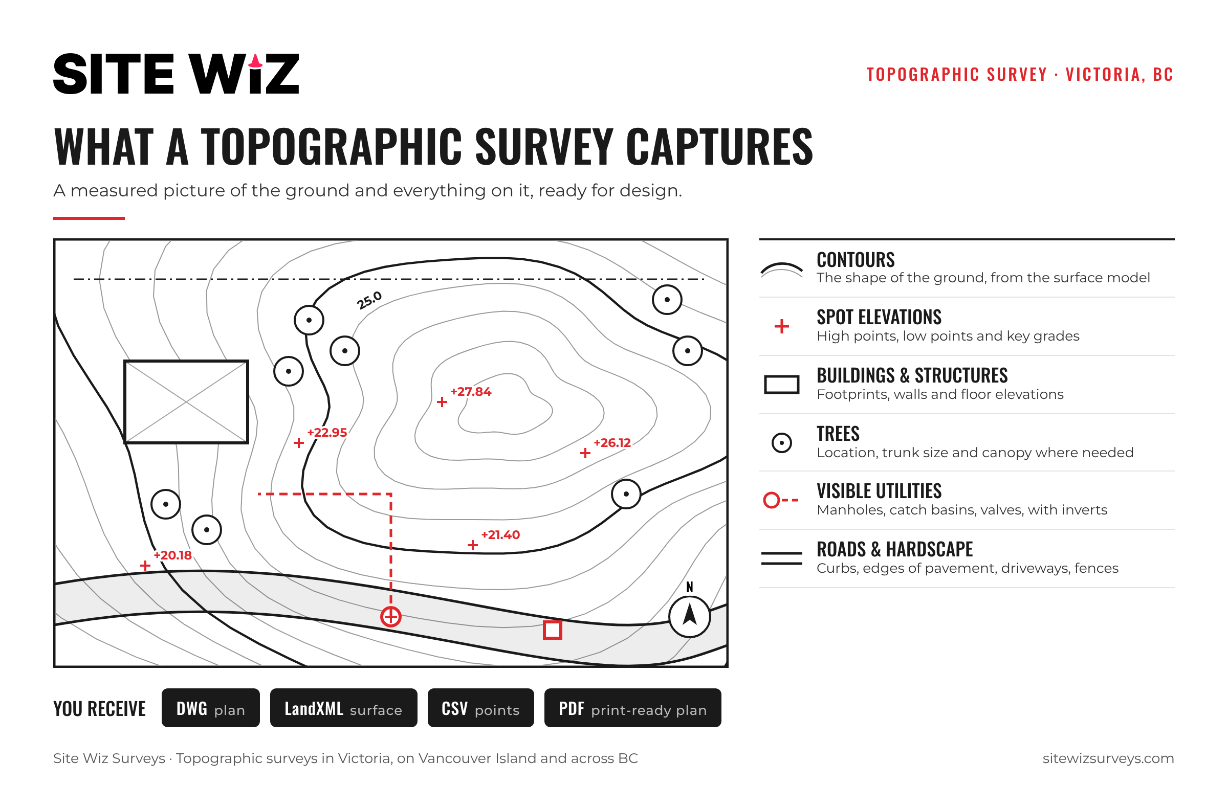
A topographic survey records the position and elevation of the ground and of the features on it. On a typical development site in Greater Victoria that includes:
- Ground shape: spot elevations, breaklines along the top and bottom of slopes, ditches and swales, and rock outcrops.
- Buildings and structures: footprints, floor or door elevations where needed, retaining walls, fences and decks.
- Trees and vegetation: tree locations and trunk sizes, and the edges of wooded areas. Many Greater Victoria municipalities have tree protection bylaws, so tree data is often part of a permit application.
- Roads and hardscape: edges of pavement, curbs, sidewalks, driveways and parking areas, often extending into the adjacent road.
- Utility structures: manholes and catch basins with rim and invert elevations, valves, hydrants, poles, pedestals and kiosks.
What You Receive
The data is processed in the office and delivered in the formats your designers use:
- CAD drawing: features, labels, spot elevations and contours, usually as a Civil 3D or AutoCAD file plus a PDF.
- 3D surface: a terrain model built from the ground shots and breaklines, ready for grading design and volume calculations.
- Point file: the raw coordinates with point descriptions, for anyone who wants to build their own model.
Architects and engineers often need slightly different detail. Our guides on topographic surveys for architects and topographic surveys for engineers cover what each typically asks for.
Scoping the Survey
Most problems with topographic data come from scope that was never agreed. Settle these points before fieldwork:
- Survey limits: the property alone, or also the road frontage and a strip of the neighbouring lots? Driveway grades and drainage often depend on what is just outside the line.
- Coordinate system and vertical datum: confirm what the designer and the municipality expect. Older drawings and newer data can use different datums, and mixing them shifts every elevation.
- Level of detail: how dense the ground shots should be, which trees to include, and whether floor elevations or roof heights are needed.
- Property lines: if the design needs them, they come from a legal survey by a BC Land Surveyor. Site Wiz provides construction and engineering surveys, not legal surveys.
- Underground utilities: request a BC 1 Call and, if needed, a private locate. The survey then picks up the locate marks along with the visible structures.
How the Fieldwork Is Done
Fieldwork starts with control: a few points with known coordinates that every measurement is tied to. The same control can later be used for layout, so the design and the stakes agree. See our guide to the construction survey control network.
The detail is then collected with GNSS (GPS) where the sky is open and a total station under trees, close to buildings and on hard surfaces where elevations matter most. On larger open sites a drone survey can capture the ground quickly, with ground checks to confirm accuracy. The right mix depends on the site; our article on field data collection explains the trade-offs.
From Topo to Construction
A topographic survey is often the first step in a longer chain. The existing ground surface it produces is used to:
- design grading and drainage, and check the design before construction. See pre-construction design review.
- build 3D machine control models for grading equipment.
- calculate cut and fill and track earthworks. See earthwork volumetric surveys.
Because the original ground is gone once excavation starts, it is worth capturing it carefully before the first machine arrives. Quantities for the whole job are measured against it.
Preparing Your Site
- Arrange access, including gate codes, keys and permission from neighbours if the survey extends onto their land.
- Share any existing drawings, previous surveys and the design brief.
- Tell us about hazards, dogs, active construction or areas that must not be entered.
- If heavy brush covers the site, discuss clearing first; dense vegetation slows the survey and hides ground detail.
Planning a project in Victoria, Langford, Saanich or elsewhere on Vancouver Island? Contact Site Wiz with the site address and what the survey is for, and we will propose a scope.
Frequently Asked Questions
What is included in a standard topographic survey?
Ground elevations and breaklines, buildings and structures, trees, roads and hardscape, and visible utility structures, delivered as a CAD drawing, a 3D surface and a point file. The exact scope is agreed for each site.
How much does a topographic survey cost?
It depends on the size of the site, the level of detail, tree cover and the deliverables required. Send us the address and the purpose of the survey for a quote.
Will the survey show my property lines?
Only if they come from a legal survey. Property lines in BC are established by a BC Land Surveyor; we can include their information in the topographic drawing.
Can you find underground utilities?
We measure the surface structures, such as manholes, valves and catch basins, and the paint marks left by a utility locate. The locate itself is arranged through BC 1 Call and private locating services.
Ground survey or drone?
Drones suit large, open areas. Ground methods are better under trees, around buildings and on paved surfaces where elevations must be exact. Many sites use both.