Why does a high-end machine control system, representing an investment of up to eighty thousand dollars, still allow a blade to dive or jump unexpectedly? It is a common frustration for site supervisors who realize that even the most advanced hardware is only as reliable as the data it receives. When a grade control surface model is built with poor triangulation or vertical inaccuracies, the result is often costly downtime while waiting for office corrections. You likely understand that the gap between a design-only file and a machine-ready model is where most field errors are born.
This article demonstrates how professional 3D surface modelling bridges that gap to ensure your equipment performs with surgical precision. By refining the data before it reaches the cab, you can achieve “one-and-done” grading passes and significantly reduce your reliance on traditional site staking. We will examine the technical requirements for seamless data flow and show you how to protect your margins by getting the model right the first time. Discover how a strategic approach to data preparation can turn your machinery into the most efficient tool on the project site.
Key Takeaways
- A professional grade control surface model serves as a virtual “design floor,” replacing traditional physical stakes with high-accuracy digital data delivered directly to the cab.
- Learn why standard engineering CAD files don’t always translate to the field and how specialized data preparation prevents machine blades from jumping or diving.
- Discover how the strategic use of breaklines and optimized triangulation creates a smoother surface for “one-and-done” grading passes.
- Understand the importance of multi-platform compatibility to ensure a seamless flow of information across Trimble, Topcon, and Leica systems.
- Realize significant cost savings by partnering with experts who can identify and correct design inaccuracies before your equipment arrives on site.
What is a Grade Control Surface Model in Modern Civil Construction?
In the context of heavy civil projects, a grade control surface model is a sophisticated digital 3D representation of a project’s finished grade. It functions as the primary intelligence for GPS-guided machinery, translating complex engineering intent into a format that dozers, graders, and excavators can interpret. This technology has effectively replaced the traditional reliance on physical stakes. Instead of an operator looking out the window for a lath or a hub, they reference a virtual “design floor” displayed on a screen inside the cab. This digital interface provides constant, high-accuracy guidance relative to the machine’s exact position on the site.
Across Canada, the industry is undergoing a definitive shift from 2D paper plans toward 3D data-driven site management. This transition allows for a level of transparency and efficiency that was previously impossible. However, a model is only as good as its construction. For a grade control surface model to be effective, it must be optimized for specific machine sensors. If the data is not prepared correctly, it can lead to blade lag, where the hydraulics cannot react quickly enough to the digital instructions. This results in “washboarding” or inaccuracies that require manual rework.
The Role of GNSS in Grade Control
Global Navigation Satellite Systems (GNSS) serve as the spatial anchor for the digital model. By communicating with a constellation of satellites, the machine determines its horizontal and vertical coordinates in real time. To achieve the millimetre-level vertical precision required for fine grading, this system relies on a localized control network established on-site. This network provides the necessary corrections to the satellite data. The result is a continuous feedback loop; as the operator moves the machine, the system compares the blade’s position to the digital surface and makes instantaneous adjustments to the hydraulics.
Why Precision Data is the New Standard
Modern contractors are increasingly adopting “one-and-done” grading strategies to remain competitive. This approach focuses on hitting the target grade on the first pass, which drastically reduces labour costs and machine hours. High-quality models also offer several practical benefits:
- Reduced Material Waste: Accurate models prevent over-excavation, saving on both haul-off costs and the need for expensive imported fill.
- Improved Safety: Fewer surveyors and grade checkers are needed on the ground near active heavy equipment.
- Regulatory Compliance: Many Canadian municipal and provincial tenders now mandate 3D data submissions to ensure project accountability and quality control.
Investing in precision data preparation is no longer a luxury; it is a fundamental requirement for the modern job site. By ensuring the model is built correctly from the outset, contractors can realize the full potential of their machine control investments.
Anatomy of a High-Performance Surface Model
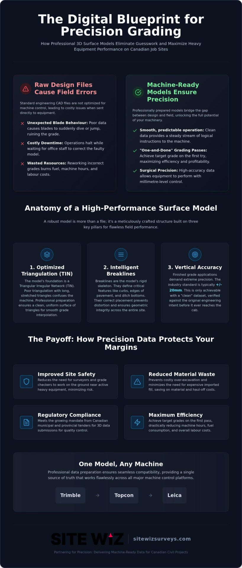
A high-quality grade control surface model is more than a simple digital file; it is a meticulously crafted geometric structure. To an operator, it represents the difference between a smooth, efficient pass and a day spent fighting the machine’s hydraulics. The integrity of this model depends on the quality of the underlying data and the logic used to connect it. For finished grade applications, vertical accuracy is typically required to be within +/- 20mm. Achieving this level of precision requires a “clean” dataset where every point and line has been verified against the engineering intent. Precision is not accidental. It is the result of rigorous data craftsmanship.
Understanding TIN and Triangulation Logic
The foundation of most 3D models is the Triangular Irregular Network, or TIN. This system connects surveyed points and design elevations to create a continuous surface of triangles. However, the size and orientation of these triangles dictate how the machine blade behaves. If a model contains “long triangles” that span too much distance without intermediate data, the machine control system may struggle to interpolate the correct elevation. This often results in the blade diving or chattering as the software tries to reconcile a lack of information. Professional data preparation involves “cleaning” these overlapping or inefficient triangles to ensure the machine receives a steady stream of logical instructions.
The Importance of Intelligent Breaklines
Breaklines act as the rigid skeleton of the 3D model. They are essential for defining sharp changes in grade, such as curb faces, swales, and crown lines. Without properly coded breaklines, the triangulation logic would simply “round off” these edges, creating a sloped surface where a vertical or sharp change should exist. Expert 3D machine control modeling services ensure that these lines are correctly identified and prioritized within the model. This prevents the TIN from crossing over critical boundaries, which preserves the design’s geometric integrity. It ensures the machine “sees” the site exactly as the engineer intended.
When the skeleton of the model is sound, the machine can move with confidence. If you’re concerned about data integrity on your next project, consider a consultation with Site Wiz Surveys to verify your files before they reach the cab. Precision starts long before the first bucket hits the dirt. A reliable model is your best defence against rework.
Design Files vs. Machine Control Models: Why ‘Free’ Data Often Costs More
A common misconception in the civil construction industry is the belief that an engineer’s CAD file is ready for immediate use in a dozer or grader. It is understandable why this assumption exists. If the design is already in a 3D format, it seems logical to simply upload it to the machine. However, engineering models are primary tools for calculating drainage and earthwork volumes, not for guiding the dynamic movements of a machine blade. Relying on these unrefined files often leads to vertical offsets, missing tie-ins at project boundaries, and “dirty” CAD layers that confuse the on-board software. When a contractor chooses to use an unverified model, they effectively accept the liability for any resulting field errors.
The ‘Engineer Model’ Trap
Design contours created by engineering firms often lack the data density required for smooth automatic blade control. There is a significant difference between “visual” 3D data, which looks correct on a computer screen, and “navigable” 3D data, which a machine can follow with millimetre precision. For instance, an engineer might use a few spot elevations to define a large parking lot, whereas a high-performance grade control surface model requires a dense grid of points to prevent the blade from searching for a grade. Professional surveyors don’t just convert these files; they re-build them using the original design intent but applying specific machine logic to ensure the hydraulics react predictably.
ROI: Calculating the Cost of Rework
The financial impact of a poor model is rarely seen in the office; it is felt on the site. While the flat-rate fee for professional data preparation is a predictable expense, the cost of a single day of idle machinery can be staggering. When an operator realizes the model doesn’t match the existing site tie-ins, the entire grading crew often grinds to a halt. Beyond labour costs, a precise model generates significant material savings. By grading exactly to the design surface, you avoid over-placing expensive gravel or asphalt. Ultimately, reducing construction rework starts with the digital model. Ensuring your data is “machine-ready” before the first bucket hits the dirt is the most effective way to protect your project’s margins.
Trends in 3D Data Preparation for Heavy Equipment
The civil construction industry is moving away from proprietary data silos in favour of greater interoperability. One of the most significant shifts is the demand for multi-platform compatibility. It’s common for modern contractors to operate mixed fleets featuring Trimble, Topcon, and Leica systems. Consequently, a grade control surface model must be versatile enough to function across these diverse ecosystems without losing data integrity. This flexibility allows site managers to deploy the best machine for the task regardless of the hardware brand installed in the cab.
Innovation is also evident in how topographic data is gathered and integrated. The use of drone-based surveys has become a standard practice for maintaining an active surface model. By capturing high-resolution aerial data, we can update the digital design with current ground conditions in a fraction of the time required by traditional methods. This ensures that cut and fill calculations remain accurate even as the site topography changes daily. Using as-built data mid-project allows for proactive adjustments, preventing minor discrepancies from compounding into major errors.
Cloud Integration and Remote Data Management
The days of driving a USB drive to the field are ending. Operators now receive model revisions wirelessly via cloud-based site links. This real-time connectivity ensures that every machine on the site is working from the same version of the truth. For multi-machine fleets, centralized data management provides a clear overview of progress and helps eliminate the office-to-field lag that often plagues complex projects. When a design change occurs in the office, it can be pushed to the cab in minutes.
BIM for Infrastructure
3D surface models are increasingly serving as the foundation for broader Building Information Modelling (BIM) workflows. This move toward digital twins provides owners with a comprehensive record of the underground and surface infrastructure for long-term maintenance. At Site Wiz Surveys, we stay at the forefront of these technological advancements to ensure our clients are prepared for the future of digital construction. If you want to modernize your site data workflow, partner with Site Wiz Surveys to implement these high-efficiency standards on your next project.
Partnering for Precision: How Site Wiz Surveys Delivers Machine-Ready Data
Site Wiz Surveys serves as the essential bridge between the engineer’s office and the machine operator’s cab. With over 20 years of industry experience, we understand that field success is contingent on data integrity. We specialize in converting 2D engineering plans into high-accuracy 3D files, ensuring that your grade control surface model is optimized for the specific dynamics of your equipment. By providing a fixed-fee service, we offer contractors a predictable cost-saving measure that eliminates the financial uncertainty often associated with data preparation. We don’t just move points; we build the digital foundation for your project’s success. This is really an extension of the broader role construction surveyors play in the construction management workflow, connecting field measurements to the digital models that every other trade and discipline now depends on.
Our role as a strategic ally means we take responsibility for the data before it ever reaches your fleet. We realize that a single day of idle machinery due to a data error can jeopardize a project’s margins. Therefore, we focus on delivering a finished product that allows your operators to work with absolute certainty. This meticulous care transforms your machine control system from a simple guidance tool into a high-performance asset capable of achieving the “one-and-done” grading passes required in today’s competitive landscape.
Our Process: From Paper to GPS
The workflow at Site Wiz Surveys begins with a meticulous verification of the original 2D engineering plans. We identify potential design conflicts, missing tie-ins, or vertical discrepancies before the 3D conversion process starts. This proactive approach ensures that the digital model is logically sound and grounded in the physical realities of the site. We also establish professional control networks to provide the necessary spatial anchor for the digital surface. Whether your project is in British Columbia or elsewhere in Canada, our support ensures your equipment stays operational and accurate from the first pass to the final grade.
Why Canadian Contractors Trust Site Wiz Surveys
Contractors across the country view us as a dedicated partner rather than a transactional service provider. There is a quiet confidence that comes from knowing your data has been prepared by a professional who understands the lifecycle of a civil construction project. We don’t just deliver a file; we provide the reliable backbone for your entire operation. Our commitment to excellence and attention to detail ensures that your technical requirements are handled with the highest level of expertise. If you are ready to eliminate costly field errors and optimize your machine efficiency, contact us for high-accuracy 3D surface modelling and experience the difference that professional data preparation makes.
Advancing Site Efficiency with Machine-Ready Data
The success of a modern civil project depends on the quality of the information delivered to the machine cab. A high-performance grade control surface model is the essential link that turns complex engineering intent into precise physical reality. By moving beyond unrefined CAD files and embracing professional data preparation, contractors can eliminate the vertical inaccuracies that lead to costly rework and idle equipment. The shift toward cloud-integrated, multi-platform environments means that having reliable, machine-ready data is more critical than ever for maintaining a competitive edge in the Canadian market.
Site Wiz Surveys provides the technical expertise needed to bridge the gap between design and execution. With over 20 years of civil surveying experience, we offer fixed-fee data preparation that ensures your project stays on budget and on schedule. Our national service coverage across Canada means your fleet can operate with total confidence, regardless of the project’s location or complexity. Precision is a choice that begins in the office and pays dividends in the field.
Optimize your next project with professional 3D modelling from Site Wiz Surveys. We look forward to helping you achieve a higher standard of precision and efficiency on your next job site.
Frequently Asked Questions
What file formats are typically used for a grade control surface model?
The primary file formats for a grade control surface model depend on the hardware platform, with Trimble typically using .ttm, Topcon utilizing .tn3, and Leica often requiring .xml or .dxf files. While LandXML is a versatile exchange format, it usually requires further refinement to ensure it functions correctly within a specific machine’s on-board software. We provide files optimized for the exact system your fleet uses to ensure seamless data integration without field errors.
Can I use a 3D model from my engineer for GPS machine control?
While an engineer’s 3D model provides a visual representation of the design, it is rarely ready for direct use in GPS machine control. These files often lack the dense triangulation and specific breaklines needed to guide a machine blade accurately across complex grades. Using unrefined design data can lead to hydraulic lag or vertical errors, making professional conversion essential for field success and project integrity.
How long does it take to prepare a professional 3D surface model?
Preparation time varies based on the complexity of the project, though most professional models are completed within two to five business days. A simple parking lot may be ready sooner, while a complex interchange with intricate drainage requires more time for meticulous verification of every tie-in. We prioritize accuracy over speed to ensure that the data you receive is ready for immediate field execution without further office support.
What is the difference between a TIN surface and a contour-based model?
A triangular irregular network (TIN) surface creates a continuous mesh of triangles that provides an elevation at any given coordinate, whereas a contour-based model relies on linear paths. Machines struggle with contour models because the software must interpolate or “guess” the elevation between the lines. A TIN-based grade control surface model ensures the machine’s hydraulics receive constant, precise instructions regardless of the blade’s position on the site.
Do I still need physical stakes if I am using a grade control surface model?
You don’t need a traditional forest of stakes, but a limited number of physical markers are still required for system calibration and quality control. These “hub and tack” points allow the operator to verify that the GPS system is reading the localized control network correctly. While staking requirements are reduced by up to 90 percent, these strategic reference points remain a critical safeguard for vertical precision and site accountability.
How do I ensure my surface model tie-ins match the existing site conditions?
Ensuring design tie-ins match the existing site requires a localized topographic survey before the model is finalized. By capturing current ground elevations at the project boundaries, we can adjust the digital model to meet the physical reality of the site. This process prevents “cliffs” or drainage issues where the new construction meets existing roads or adjacent properties, ensuring a seamless transition between new and old surfaces.
What happens if there is a design change mid-project?
If a design change occurs, the digital model is updated in the office and the new version is pushed to the machine cab, often via a cloud-based link. This ensures the operator is always working from the most current revision. Because the system is digital, these changes can be implemented far more rapidly than traditional restaking, keeping the project on schedule despite engineering revisions or client requests.
Is professional data preparation expensive compared to doing it in-house?
Professional data preparation is a strategic investment that often costs less than the rework caused by in-house errors. Specialized surveyors possess the advanced software and niche expertise required to identify design flaws that an in-house team might overlook. By utilizing a fixed-fee service, contractors can budget predictably while ensuring their high-value machinery operates at peak efficiency from the moment it arrives on site.