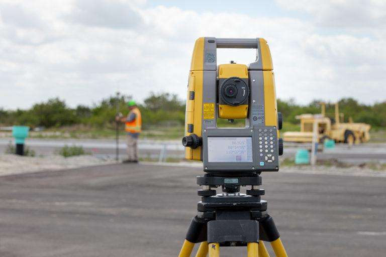
Surveying equipment is essential for anyone involved in construction, engineering, or mapping. From traditional instruments like theodolites and levels, to modern technology like GPS and laser scanners, surveying equipment has come a long way in helping professionals gather the precise data needed for a wide range of applications. In today’s article, we’ll take a closer look at some of the most common types of surveying equipment and how they are used.
Levels:
A level is a tool used to determine the height of a specific point relative to a reference point. It works by using a spirit or bubble level to establish a horizontal plane, by taking a measurement from that plane to the point of interest. This measurement can be used to determine the height of the point, as well as its elevation relative to the reference point. Levels are commonly used in construction, engineering, and land surveying to ensure that surfaces are level and to establish the elevations of various points on surfaces. Levels can be either visual based, relying on the user to visually determine the reading or bar-code based electronic units that electronically determine each reading.

Theodolites:
A theodolite is a device that is used to measure angles. It consists of a telescope mounted on a tripod and a rotating plate. This allows the surveyor to measure the horizontal and vertical angles of the target. Theodolites are typically used in combination with other surveying equipment, such as total stations and GPS receivers, to provide highly accurate measurements of the location and orientation of points on a site. Theodolites are being replaced by newer technology more and more, however they are still an inexpensive way to achieve precise measurements when used by qualified operators proficient in trigonometry.
Laser Rangefinder:
A laser rangefinder is a device that uses lasers to measure distances quickly and accurately. In surveying, laser rangefinders are used to measure the distance between two points on the ground, such as the height of a building or the distance between two property boundaries. Laser rangefinders are typically handheld and easy to use, making them a popular choice for interior floorplan surveys required in strata or condominium developments, measuring the heights of overhead wires between utility poles, or for other types of quick and accurate physical measurements.
GPS Receivers:
A Global Navigation Satellite System (GNSS), is a network of satellites that orbit the earth and transmit signals that can be used to determine the precise location of a receiver on the ground; a GNSS receiver. Surveying GNSS receivers are typically more accurate than the ones found in smartphones and other consumer devices as they use RTK (Real-time kinematic) carrier-based ranging, and they can be used to measure the position of points on a construction site with incredible relative precision down to the centimeter or in ideal conditions a few millimeters. Surveying GNSS receivers are often used in combination with other surveying equipment, such as Robotic total stations, to develop even more accurate measurements by using hybrid surveying methods.

Total Stations:
A total station is a device that is used to measure both angles and distances. It consists of a telescope mounted on a tripod, which is used to aim at a target, and an electronic distance meter, which uses lasers or infrared light to measure the distance to the target. Total stations provide measurements of location and orientation to the highest degree of accuracy. Essentially it is a theodolite and rangefinder integrated into one combined unit. Total stations provide the highest accuracy. They require at a minimum a 2-person crew.
Robotic Total Stations:
A robotic total station combines all the integration found in a total station with the addition of servo or magnetic drive motors that aim the scope at the target prism automatically and allow the operator to control the device remotely via 2-way communication between the stationary robot and the surveyor who collects data via a field computer known as a data collector. These units utilize algorithms to track and lock onto a roving prism, and have allowed a single user to perform tasks that would otherwise require 2 people.
Surveying Equipment Selection: Tips and Considerations
Each type of surveying equipment is designed for specific applications and have their own unique features and benefits, however modern technologies such as the Total Station combine many of the capabilities of the individual tools. Total stations are highly precise and are commonly used for detailed surveying tasks, while GPS receivers are typically used for large-scale mapping applications. In general, surveying equipment is an essential tool for a wide range of applications and can help professionals accurately measure and map the world around us.
In general, surveying equipment is an essential tool for a wide range of applications that professional surveyors like Site Wiz Tech utilize to improve the quality of their services.
Experience the Benefits of Advanced Surveying Equipment in the Hands of Our Expert Team
Our expertise in using advanced surveying equipment can save you time, prevent costly mistakes, and help you complete your project efficiently. Get in touch to learn more about how our expertise can utilize surveying tools to optimize the course of your project.