A volume can be calculated correctly and still be difficult to compare with project records. The issue may be the surfaces, not the arithmetic. This earthwork volumetric survey guide explains why the comparison basis matters, including whether quantities are measured against existing ground, a design surface or an earlier survey.
A useful quantity report identifies the surfaces and data used to produce it. Results can be hard to interpret when inputs use different coordinate or elevation references, cover different areas, or rely on unstated surface assumptions. Before comparing quantities, check that the report names the surfaces, calculation limits and files used.
This guide covers how to match a volume method to the project question, what to include in a survey-data package and when field surveying or remote processing may be appropriate. Field surveying can provide new site data. Remote Volumetric Calculations use supplied project data and do not include physical field collection.
Key Takeaways
- An earthwork volumetric survey in BC is meaningful only when the compared surfaces and measurement basis are identified.
- Choose the calculation approach to suit the decision, such as estimating planned quantities, tracking progress or measuring a stockpile.
- Check that survey inputs cover the work area and use a suitable shared reference before relying on a surface comparison.
- Confirm whether new field data is needed or whether supplied project data can support remote Volumetric Calculations.
What an Earthwork Volumetric Survey Measures, and Why the Basis Matters
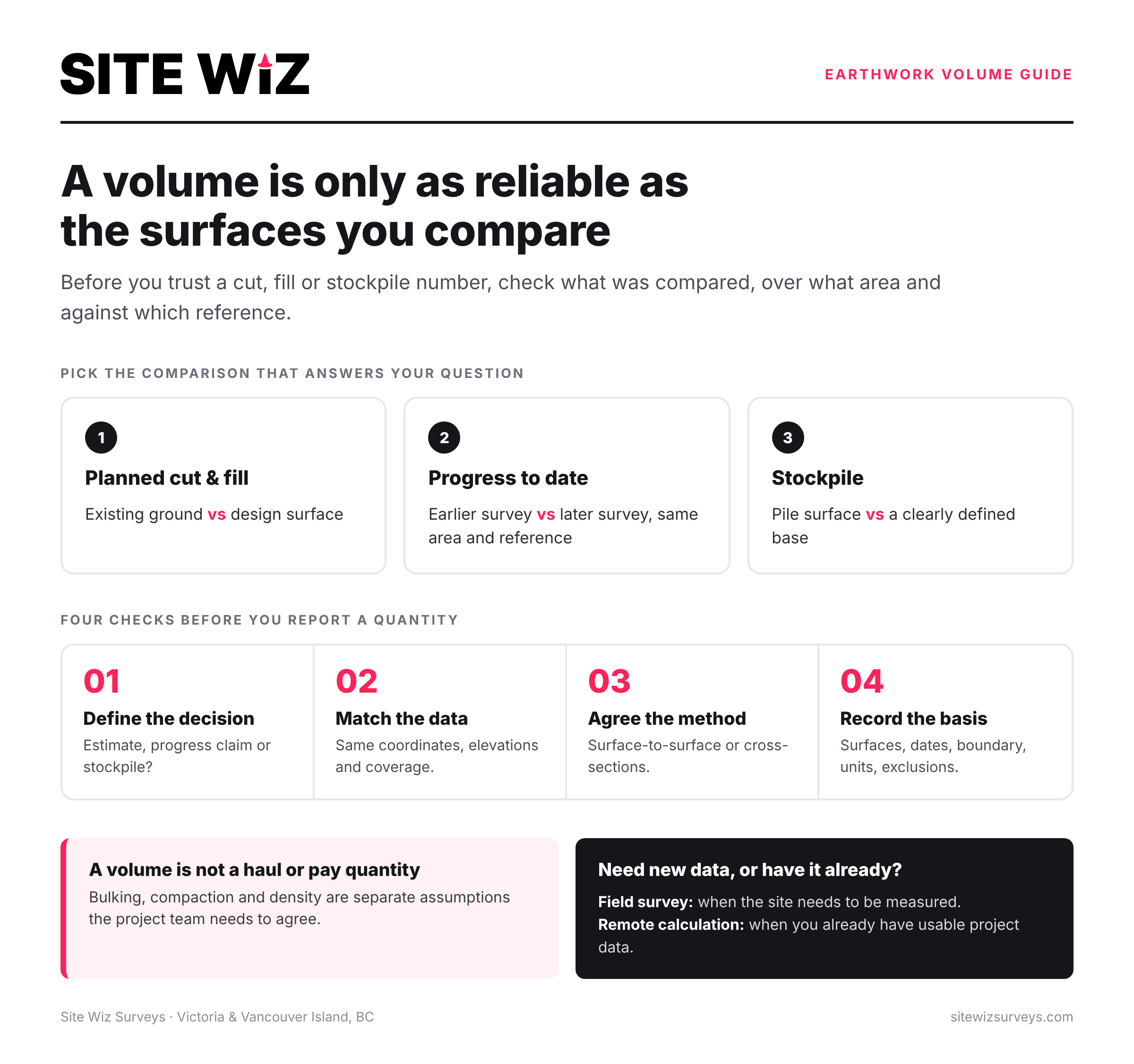
An earthwork volumetric survey calculates material quantities from site or design data. The result needs to be read alongside the surfaces and assumptions used to produce it. On an earthwork project in BC, start by defining the question: are you estimating planned cut and fill, checking progress or measuring a stockpile? Each requires a different comparison and answers a different question.
For planned work, comparing an existing-ground surface with a design surface can show where material is expected to be removed or placed. This follows cut and fill principles, where excavation and embankment quantities help describe how earth is moved across a site. A stockpile calculation uses a surface representing the pile and a defined base. Progress measurement compares site conditions at different stages.
Which surfaces are being compared?
For progress tracking, compare two dated surfaces that cover the same relevant area and use a suitable shared reference. The report should name each surface, give its date and define the calculation limits. A comparison between a design surface and a previous survey answers a different question than a comparison between two site surveys. Confirm which comparison is required before interpreting the result.
What does a volume result tell the project team?
A volume can support planning, progress review and material management, but it does not automatically state how much material will be hauled or paid for. A calculated volume is separate from conversions based on density, bulking or compaction. Those assumptions need to be considered separately and agreed by the project team.
Before using a result, confirm the calculation method and scope, including the surfaces, measurement limits and units. Check whether exclusions or other assumptions affect the comparison. Without this context, quantities from separate reports can be difficult to reconcile, even when each calculation has been processed consistently.
How Earthwork Volumetric Calculations Turn Survey Data into Quantities
A clear calculation workflow starts with the project question, assembles the relevant inputs, selects a calculation basis, reviews the result and records the method and scope. On an earthwork project in BC, this sequence helps the team understand what the quantity represents and how to compare it with other project information.
A digital terrain surface is a three-dimensional representation of ground elevations used as an input for comparing site conditions and calculating volume. Where compatible surfaces are available, a surface-to-surface comparison can calculate the difference between them across a defined area. Cross-section calculations may also be suitable, depending on project requirements and the supplied data. Agree on the method before processing begins.
What data should be assembled before calculation?
Gather surfaces that match the question: existing ground and design for planned quantities, or dated surfaces for a progress comparison. Provide available coordinate and elevation information, the calculation boundary, survey dates and file context showing which surface represents each stage. Do not assume that files are comparable just because they cover the same site. Check how their references and limits relate.
How should the calculation basis be documented?
Record the surfaces and dates used, the boundary applied and whether the method was a surface comparison or cross-sections. Note exclusions and assumptions that could affect interpretation. For construction work, check the project’s applicable specifications and measurement or payment requirements before reporting quantities. For more on presenting results, see our guide Volume Calculation Survey Reports: A Comprehensive Guide for Civil Contractors.
If you have project data and want to check whether it may support remote processing, contact us about the calculation scope.
How to Check Survey Inputs and Choose a Practical Volume Workflow
Start with the decision the quantity needs to support: estimating planned earthworks, comparing progress between dates or assessing a stockpile. Then check whether the supplied surfaces represent that question and cover the full calculation area. If surfaces do not use a suitable shared coordinate and elevation reference, they may not align for a meaningful comparison.
Before calculation, confirm the boundary, surface dates, exclusions and requested deliverable. If the distinction matters, specify whether the result should separate cut and fill or report a combined quantity. These details help prevent a processed number from being mistaken for a different measurement.
Interpret a volume report using its stated surfaces, dates, reference, boundary, exclusions and calculation method.
When is new field data needed?
New field data may be needed if the available surface does not represent current site conditions. This can matter when assessing progress or measuring a stockpile that has changed. Site Wiz Surveys provides Topographic Surveys as a field service in British Columbia. Review its Topographic Survey field service information and confirm the location and scope for your project.
When can remote volumetric calculation fit?
Remote processing may suit a project when relevant survey or design data has already been collected and supplied. Site Wiz Surveys’ remote Volumetric Calculations use client-provided data; remote calculation does not mean we collected the field data. If inputs are incomplete or their reference is unclear, resolve those issues before relying on the result as a comparison.
For any earthwork volume calculation, match the method to the project decision and check the inputs before calculation. This makes the result easier to review and hand off.
How Site Wiz Surveys Supports Earthwork Volume Workflows
An earthwork volume workflow may require new site data, remote calculation or separate steps for both. Site Wiz Surveys offers Topographic Surveys in British Columbia when a current site surface is needed, and remote Volumetric Calculations when suitable survey or design data is available. Remote processing uses client-provided data and does not include field collection by our team.
Choose a starting point based on the project question and the condition of the available inputs. If a supplied surface does not represent current ground conditions, discuss whether a Topographic Survey in British Columbia is appropriate. If the required surfaces and comparison basis are available, remote Volumetric Calculations may fit the scope. Learn more about remote volumetric calculation services.
What to include in a project enquiry
Describe the site question and quantity required, such as planned cut and fill, progress change or stockpile volume. Identify the available existing, design or dated surfaces, as well as the calculation boundary and any exclusions. Include the reporting context, such as the project stage or how the quantity will be reviewed. State whether you are considering new field data or remote processing. These details help clarify the scope before work begins.
For guidance on documenting the result, see the earthwork volume calculation report guide. If the requirement is broader estimating rather than a surface-based volume, the related article on civil quantity take-off surveying services may help distinguish the scope. Neither pathway implies survey hardware sales or guarantees a project outcome.
Share the project question and available data to discuss which service may fit the scope.
Make Your Earthwork Quantities Easier to Interpret
A useful earthwork volumetric survey in BC begins with a clear project question and comparison basis. Confirm which surfaces, dates and boundaries support the calculation, then document the method and assumptions. This context helps project teams interpret quantities consistently, whether they are estimating planned work, reviewing progress or managing stockpiled material.
When new site information is needed, we provide Topographic Surveys in British Columbia. When suitable project data is available, its remote Volumetric Calculations service can process the supplied inputs without field collection. Site Wiz Surveys was founded in 2021, and its founder has over 20 years of industry experience.
With the relevant inputs and a defined scope, volume results are easier to review and use in project discussions.
Frequently Asked Questions
What is an earthwork volumetric survey?
An earthwork volumetric survey uses site or design data to calculate material volume within a defined area. An earthwork volumetric survey BC project might compare existing ground with a design surface for planned cut and fill, compare dated surfaces to assess site change, or measure a stockpile against a defined base. The result should identify its surfaces, boundary and assumptions so the project team can interpret the quantity.
How are earthwork volumes calculated from survey data?
Earthwork volumes are calculated by defining the area and surfaces to compare, then applying a method suited to the available data and project requirements. Compatible digital surfaces can be compared across a defined boundary; other approaches may also be appropriate. The report should state the inputs and calculation basis. A volume calculation alone does not determine material density, conversion factors or assumptions outside its scope.
What survey data is needed for an earthwork volume calculation?
The required inputs depend on the quantity question. They may include existing-ground data, a design surface, dated comparison surfaces or a stockpile surface, along with the relevant boundary and project context. Provide available coordinate and elevation information, surface dates, exclusions and the requested output. Confirm these details with the calculation provider before work begins, since not every supplied file will suit the intended comparison.
Can volumetric calculations be completed remotely?
Yes, remote Volumetric Calculations may be possible when suitable survey or design data is supplied for processing. Remote work means calculating from provided information; it does not mean the provider physically surveyed the site. If new field observations are needed, arrange field surveying separately and confirm availability for the project location. Site Wiz Surveys provides remote Volumetric Calculations, distinct from its field-data collection services in British Columbia.
When should a contractor request a new topographic survey instead of using existing data?
Consider new field data if existing surfaces do not represent the site condition relevant to the calculation, omit part of the required area or cannot be interpreted against the intended comparison. The decision depends on project scope and available information. Site Wiz Surveys provides Topographic Surveys as a field service in British Columbia. Confirm the required survey scope and location before proceeding; remote calculation uses supplied data and does not collect new field observations.
To discuss a volume calculation, share the project question and the survey or design data available with Site Wiz Surveys.